Lake Minnetonka Points
They aren’t just names on a map. Bohns Point. Brackett’s Point. Casco Point. Fagerness Point. Hardscrabble Point. These are the places where Lake Minnetonka reveals its character — and its secrets.
Points mark more than shorelines. They signal outlooks, headlands, and vantage points — often the first to be settled and the last to change hands. From the Dakota’s sacred stones to Gilded Age summer estates, the points of Lake Minnetonka have long attracted those who want something more than lakefront. They want legacy. They want view. They want a presence on the water.
Some points have been private retreats. Others, like Gibson’s Point, are quietly held by descendants of Minnesota’s earliest horticulturists. And some, like Brackett’s Point, remain synonymous with the state’s founding families and architectural treasures.
Each point has a story. Some are still unfolding.
We invite you to explore them one by one.
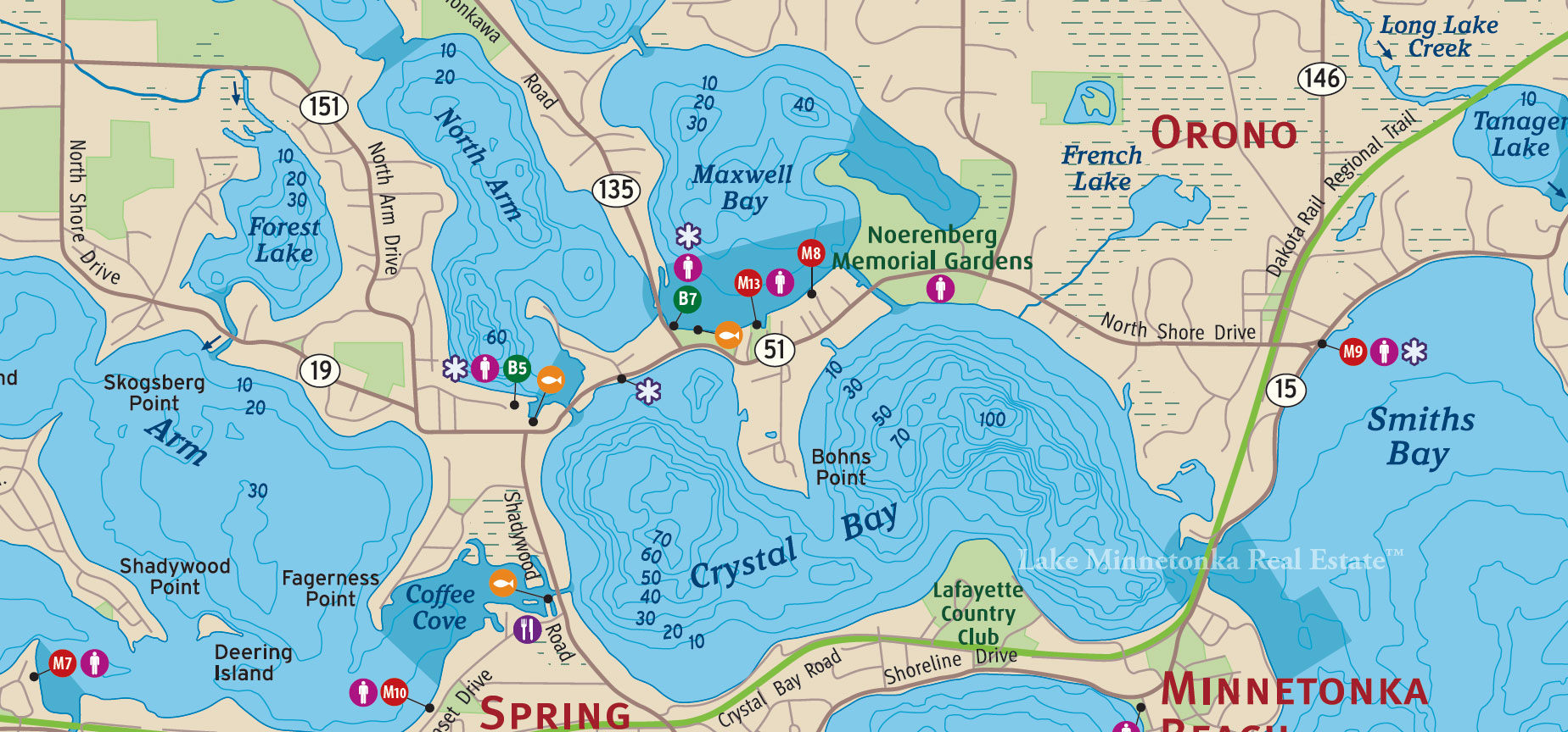
A long, elegant arm of land that stretches confidently into Crystal Bay, Bohns Point offers western sun, deep water, and some of the most architecturally ambitious estates on the lake. With panoramic views of the Arcola Bridge and the far end of Smiths Bay, it’s a favorite among those who value both privacy and proximity. Many homes here are tucked behind gates and mature trees, and several feature their own deepwater docks — perfect for larger vessels. This is Crystal Bay’s quiet power — a point that speaks not with flash, but with permanence.
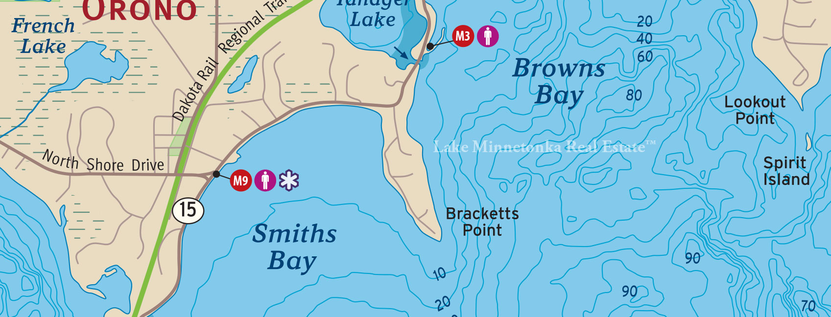
There’s no mistaking Bracketts Point on the map — or in the imagination. A long, high peninsula reaching into the Lower Lake, Bracketts is home to some of the most significant estates in Minnesota, including the iconic Southways, a former Pillsbury family residence that once defined Minnetonka grandeur.
Originally named Starvation Point, the land was claimed in the 1880s by George Augustus Brackett, a Minneapolis lumberman and mayor who saw more than shoreline — he saw permanence. The point’s position, elevation, and protection from wind made it ideal for boating and building alike. William Hood Dunwoody followed with Pennhurst. Eventually, the Pillsbury family acquired the land and built Southways, with its miles of stone walls, formal gardens, and commanding views across the lake.
Today, Bracketts Point remains synonymous with legacy real estate on Lake Minnetonka. Deepwater docks, long setbacks, and some of the last truly grand lawns on the Lower Lake define this stretch of shoreline. Many homes remain hidden from the road — and intentionally so. Access is discreet. Listings are rare. But for those who understand what’s here, Bracketts is not just a point. It’s a pinnacle.
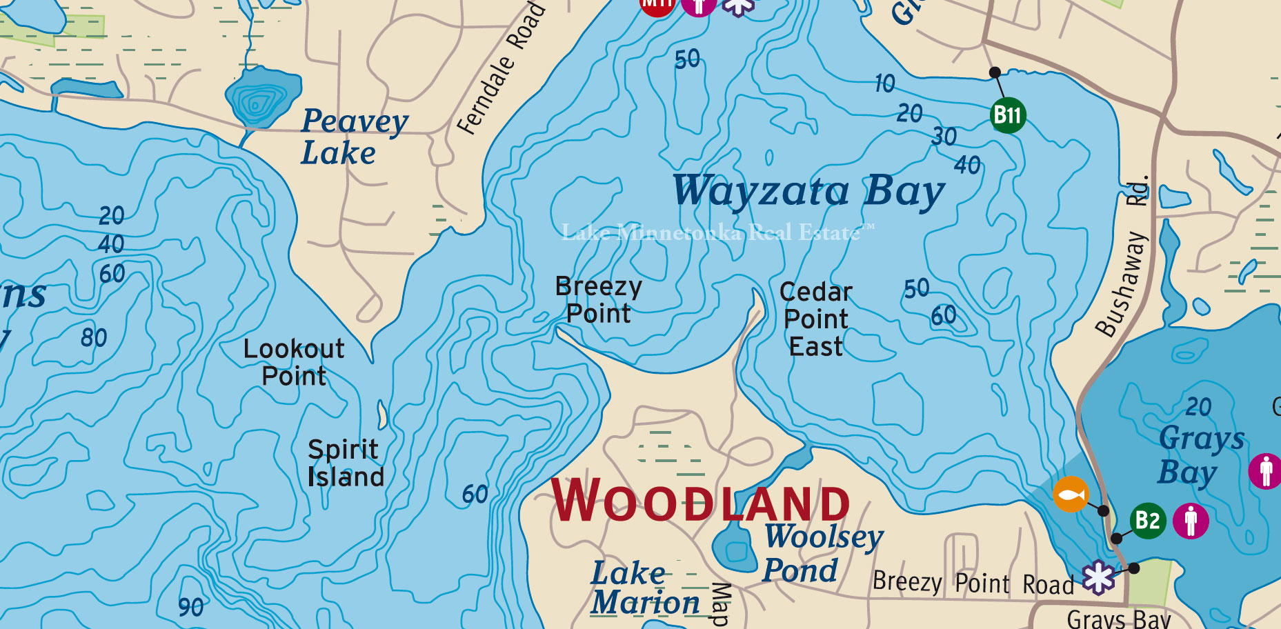
Tucked into the eastern edge of Wayzata Bay, Breezy Point lives up to its name — a slender stretch of land known for its constant movement of light and air. With water on three sides and the skyline of Wayzata just across the bay, it offers a rare blend of proximity and privacy.
Originally dotted with simple summer cottages, the point evolved over time as families discovered its elevated views and gentle breezes. Today, many of those original structures have given way to thoughtfully designed year-round homes, but the feeling remains the same: sun-warmed decks, dockside mornings, and the easy bike ride into town.
Breezy Point sits within the Minnetonka School District and is part of the city of Woodland — one of the smallest and most discreet municipalities on Lake Minnetonka. It’s not flashy, but that’s the point. Here, lake life unfolds a little more quietly — with sailboats in the distance and the porch light always on.
Casco Point
Casco Point extends like a brushstroke between Carman Bay and Spring Park Bay — a narrow, walkable peninsula that feels like its own quiet village. Once home to summer cottages and a lakeside hotel, the point has long attracted those drawn to its water views in nearly every direction and the nostalgic ease of its layout.
Many of the homes here retain their original charm — a mix of renovated cabins, classic lake cottages, and updated year-round residences. Properties often feature level shoreline, mature trees, and private docks just steps from the back door. Some have remained in the same family for generations.
Casco is part of the City of Orono and falls within the Orono School District. It’s a point that lives like a neighborhood, where the streets curve with the land, and neighbors still wave from porches and pontoons alike. A full circle by foot or bike takes minutes — but the feeling it leaves lingers much longer.
Cedar Point
Cedar Point East is one of the most visible pieces of real estate on Wayzata Bay. Projecting north from the Woodland shoreline, just east of Breezy Point, it sits directly across from downtown Wayzata — a front-row seat to the most dynamic stretch of water on Lake Minnetonka.
The point’s orientation offers sweeping views of sailboats, paddlers, and classic wood boats heading in and out of the Wayzata docks. But for those who live here, it’s not about the traffic. It’s about the perspective. From sunrise reflections to the golden hour glow over Wayzata’s skyline, Cedar Point East commands attention without asking for it.
Homes here range from long-held family estates to modern lakefront builds with deep setbacks and even deeper water. Residents are part of the Minnetonka School District and the tightly held City of Woodland, known for its wooded privacy and low profile — even in high-profile locations.
Cedar Point East isn’t hidden. It’s just already spoken for.
Crown Point
Crown Point forms the southernmost tip of Big Island — a rocky, windswept outpost with long southern exposure and a name that still carries weight among those who know the lake best. Surrounded on three sides by the waters of Lower Lake Minnetonka, it faces south toward Greenwood and the entrance to Saint Albans Bay, with miles of open water in between.
Unlike the public beaches and picnic grounds of Big Island’s parkland, Crown Point has always been private. For decades, a small number of lake families maintained rustic cabins or seasonal homes here, often handed down quietly or sold off-market. Access is by water only. No cars. No roads. Just dock, trail, and shoreline.
Today, much of Big Island is preserved as natural space, but Crown Point remains quietly held — a rare case of legal lake access in one of the most visually prominent, physically secluded locations on Lake Minnetonka. It is not often available. When it is, it’s not available for long.
Fagerness Point
Fagerness Point sits at the junction of West Arm and Coffee Cove in Orono — a narrow peninsula that sees some of the lake’s most consistent boat traffic, especially with Lord Fletcher’s just around the bend. But what makes this point truly special isn’t the activity. It’s the view.
Along the northwest side, Fagerness offers elevated frontage with some of the longest, cleanest sunset views on the lake — looking straight out across West Arm Bay, with no interruption. From these lots, the evening light seems to last longer. The water catches every shade of it. And the skyline stays wide open.
The point itself is a mix of legacy cabins and year-round homes, many still privately held. Shorelines curve in multiple directions, giving each property its own relationship to the water. The eastern side is more active, facing Coffee Cove and the main channel. The western side, despite its popularity among boaters, retains a kind of quiet elevation — both literally and figuratively.
Located in the City of Orono and the Westonka School District, Fagerness Point offers a rare combination: water on both sides, sun where you want it, and an address that very few ever let go.
Fergusons Point
Fergusons Point marks the western edge of Carson’s Bay in Deephaven — a quiet, deeply held stretch of shoreline that’s seen summer cabins evolve into legacy estates over more than a century. Named for William H. Ferguson, who settled here in 1854 as one of the area’s first orchard owners, the point became part of the early fruit-growing corridor before taking on new life through generations of lake families.
By the turn of the 20th century, portions of the point were acquired by the Gluek family of brewery fame, cementing its reputation as one of the most desirable addresses on the Lower Lake. The land is elevated, the shoreline protected, and the sun exposure balanced between morning and afternoon — especially on the eastern and southern sides facing Carson’s Bay.
Part of the Minnetonka School District and just minutes from Cottagewood and Excelsior, Fergusons Point is unassuming in name but rich in history. These are homes with long stories, held tightly, and passed with care.
Gibsons Point
Gibsons Point forms the southeastern edge of Lower Lake North, curving into the entrance of Northome Bay in Deephaven. The point is named after Sir Charles Gibson, a St. Louis attorney and Civil War veteran who owned over 200 acres in the area. Local lore claims the land was a gift from President Abraham Lincoln for Gibson’s service to the Union — and whether apocryphal or not, the point has held a quiet stature ever since.
In 1876, Gibson built a Gothic-style summer home here and named it Northome, his home “up north.” The home stood as a landmark until the estate was later subdivided, making way for some of the most desirable lakefront parcels on the Lower Lake. Today, Gibsons Point remains a private stretch with south-facing shoreline, protected water, and legacy-level ownership.
Part of the Minnetonka School District and close to both Cottagewood and the Minnetonka Yacht Club, Gibsons Point sits at the intersection of tradition and access. Two historic boathouses still line the shoreline — one said to have served as a streetcar boat stop. Like the homes here, they don’t draw attention. They simply belong.
Grandview Point
Grandview Point extends into Carson’s Bay from the north, a spoon-shaped peninsula in Deephaven known for its high banks, broad water exposure, and proximity to Lighthouse Island and the Minnetonka Yacht Club. With elevation on both sides and views in every direction, it’s a point designed by nature for perspective — and claimed early by those who knew how to build legacy.
Samuel C. Gale once owned the land. In 1910, Cream of Wheat founder Emery Mapes acquired it, and by 1925, his daughter Alla and son-in-law C.V. Thomson had built a sixteen-room Georgian-style mansion with columns, porches, and lake views on all sides. The estate was later subdivided into a small enclave of premium lake homes, many perched above steep slopes with private access to the shoreline below.
In 1974, modernist architect Ralph Rapson designed a home for David and Joan Wyer at the edge of the point — a now-iconic series of cantilevered wooden cubes clinging to the bank, suspended above the water and forest below. Grandview has continued to attract architectural ambition and long-term ownership ever since.
Today, Grandview Point remains one of Deephaven’s most architecturally significant and tightly held locations — protected on three sides, walkable to the yacht club, and oriented for evening light. Part of the Minnetonka School District, it is not a place that turns over often. And when it does, it rarely turns public.
Hardscrabble Point
Hardscrabble Point reaches between Cook’s Bay and Priest Bay, forming one of the most prominent peninsulas on the Upper Lake. Once a quiet finger of land in Minnetrista, it’s now home to some of the most striking new construction on this side of Lake Minnetonka — a shift that speaks volumes about how the shoreline has changed, and who it now draws.
The name may recall simpler times, but the properties say otherwise. Longtime cabins have been replaced by architect-designed homes with broad west-facing decks, smart dock layouts, and floorplans built for both privacy and view. Even Jimmy Jam’s former lakefront estate once stood here — since replaced by two new custom homes that speak to the land’s continued evolution.
Both sides of the point offer water: Priest Bay to the east, for calm mornings and protected dockage; Cook’s Bay to the west, for sunset and open water feel. The elevation is subtle but present, and the lots run long — giving each home just enough distance to feel private, even in full view from the lake.
Part of the Westonka School District and the City of Minnetrista, Hardscrabble Point has become something more than a landmark. It’s a signal — that the Upper Lake is no longer secondary. And that modern Minnetonka luxury now reaches as far west as it needs to.
Howard Point
Howard Point forms the northwestern edge of Upper Lake Minnetonka, pointing toward Shady Island and the entrance to Smithtown Bay. Located in the City of Minnetrista, the point is best known today as home to Howard’s Point Marina, a full-service operation that’s been supporting lake access since 1926. But long before the gas pumps and lift slips, this land was home to the Howard family — early settlers who gave the point its name.
The point itself is a natural marker on the lake — curving gently into the open water with protected shoreline along both sides. Its tip points north, toward the cluster of islands that define this stretch of the Upper Lake, including Shady, Wawatasso, and Eagle. It’s said the last Native American encampment on the lake was located here, a quiet but significant detail that ties this land to a much deeper history.
Today, Howard Point blends activity and legacy. The marina bustles in summer with rentals, fuel, and dock service, but private homes along the point retain a calm, almost understated rhythm. Many offer long views across open water or wooded privacy along the shore.
Part of the Westonka School District, Howard Point remains one of the Upper Lake’s most enduring landmarks — where access, history, and horizon meet.
Huntington Point
Huntington Point curves south into Lower Lake Minnetonka from Minnetonka Beach — a slender peninsula just west of Lafayette Bay, bordered by open water on three sides. Once known as Holmes Point, it was renamed for W.W. Huntington, an early landowner whose name has remained tied to this stretch of shoreline for over a century.
The homes here are set back and discreet, but the waterway is anything but quiet. Huntington Point sits directly along one of the busiest boating thoroughfares on the lake — a channel that funnels weekend traffic between the Arcola Bridge and Big Island. From the dock, it’s a front-row seat to the lake’s energy: pontoons, wakesurfers, sailboats, and classics all gliding past, especially in high summer.
Historically, some of the earliest cabins on the point were said to have been floated across the ice from Big Island — a sign of the land’s long-held appeal. Today, the point remains private and well-held, with many homes updated or replaced but never overdone. The elevation is gentle, the sun exposure excellent, and the access — both visual and physical — unmatched.
Part of the Orono School District and located within the City of Minnetonka Beach, Huntington Point offers a rare blend of privacy and presence. It doesn’t hide. It just knows its place.
Locke Point
Locke Point, also known historically as Lithgow’s Point, reaches into Old Channel Bay on Lake Minnetonka’s southern edge. Today, it’s home to the private, gated community of Clay Cliffe — but its story begins in the 1850s, when William Lithgow drowned off the point and lent it his name. In 1871, the land was purchased by horticulturalist Peter Gideon to expand his orchard operation. Later, it passed to Fred B. Snyder, a Minnesota legislator and attorney who built a stately home here in 1910.
The peninsula covers roughly 20 acres and includes over half a mile of shoreline. Elevated and wooded, it offers a protected setting with water views on three sides — a feature that once attracted settlers, then fruit growers, and eventually architects. The current Clay Cliffe community retains elements of the original Snyder estate, including its entry gate lions. Residents today enjoy amenities like tennis courts, a gazebo, and managed grounds — all behind gates, and all along one of the lake’s more discreet southern shores.
Located in the City of Tonka Bay and within the Minnetonka School District, Locke Point is part legacy, part reinvention — a place where the shoreline still shapes the community.
Lookout Point
Lookout Point sits at the southernmost edge of the Ferndale peninsula in Wayzata — a dramatic rise of land that offers sweeping, elevated views over Wayzata Bay, Big Island, and the open lake beyond. In the early maps, it was sometimes referred to as Point Lookout, and its prominence is more than topographic. This is sacred ground, layered with centuries of meaning.
Just offshore is Spirit Island, long believed to be a ceremonial site for the Dakota, and associated with the spiritual counterpart of nearby Spirit Knob. According to oral history and early local sources, the Dakota viewed these places as traditional cultural properties — tied to ceremony, burial, and the spiritual geography of the lake.
In the late 1800s, Lookout Point became part of Harrington Farms, claimed by brothers John and William Harrington, who also built the lake’s first summer boarding house nearby. The land was later acquired by members of the Pillsbury family. In 1915, the granite Harrington Gate was constructed at Ferndale Road to mark the boundary between the growing village and this quiet stretch of shoreline.
Today, Lookout Point remains private, wooded, and steeped in legacy. Homes here are shielded by trees, but from the water, the elevation tells you everything. This was — and remains — one of the highest vantage points on Lake Minnetonka. Not just a view, but a place to understand the lake’s full scale, both natural and human.
Part of the Wayzata School District and accessed by the private lanes of Ferndale and Harrington Road, Lookout Point isn’t just a place to live. It’s a place to belong — if invited.
Pelican Point
Pelican Point curves into the north side of Spring Park Bay, once a quiet corner of the Upper Lake, now a lively stretch of water flanked by history and fresh energy. Named for the white pelicans that still visit in spring and fall, the point was long favored by the Dakota for its wild rice beds and sheltered fishing grounds.
By the mid-1800s, settlers from Minnetrista and Mound began to claim the surrounding shoreline. While Spring Park grew into a resort-era hub, Pelican Point held to a quieter rhythm—wooded lots, long docks, and riparian rights passed down quietly through generations.
Today, the area hums with activity. Across the bay, the Shoreline Hotel brings boutique hospitality and coastal dining to the lake. Next door, the Hennepin County Water Patrol stands watch as wake boats and pontoons fill the summer scene. And yet, Pelican Point still feels set apart—close enough to the action, far enough to keep its cool.
Legacy lives here. So do sunrises, still mornings, and the names that don’t need to be listed.
Point Charming
Point Charming lines the northeast shore of Big Island, facing southeast into the broad open water of the Lower Lake. There’s nothing tucked away about it — from this stretch of shoreline, you see the lake at full volume: early light, long horizon, and weekend boat traffic stretching toward Big Island’s deeper coves and the edge of St. Louis Bay.
There’s energy here. And visibility. Homes along Point Charming are water-access only, but they live large — with full sun, open air, and a constant sense of motion on the water. Docks face into the main lake, not behind it. And while the name may feel whimsical, the setting is anything but.
Part of the City of Orono, Point Charming holds just a few private properties — most with wide lakefrontage and quiet ownership. It’s not for those who want stillness. But for those who want presence — real, wide-open, sunrise-facing presence — it delivers exactly what the name promises.
Point Comfort
Point Comfort lines the southern edge of Big Island, facing east-southeast toward Deephaven and Greenwood. The name suggests solitude, but the reality is livelier. This is one of the most visible stretches of Big Island shoreline — a high-traffic zone for boats heading to Excelsior Bay, the Commons, and deeper into the Lower Lake.
The lots are water-access only and privately held, but they’re anything but hidden. From the lake, docks line the edge. Homes are partially visible through the trees. On a summer Saturday, you’re in full view of cruisers, pontoons, and paddlers drifting past at a steady rhythm.
What Point Comfort offers instead is exposure: full morning sun, open-air views of historic Deephaven homes across the water, and a front-row seat to lake life in motion. You can spot the top of the Commons pavilion in Excelsior, or watch Cottagewood’s shoreline glow in late evening light. It’s connected — geographically and socially.
Located in the City of Orono, Point Comfort is part of Big Island’s more public-facing perimeter. Not quiet. Not tucked away. But unmistakably present.
Recreation Point
Recreation Point forms the westernmost tip of Big Island, facing Huntington Point across the channel and offering commanding sunset views over the Lower Lake. Despite its name, this point has never been about public access. It’s been private from the start — quiet, water-only, and architecturally rooted in one of the most interesting stories on the lake.
The original cottage here was built in the 1880s by C.F. Haglin, the Minneapolis contractor behind the Foshay Tower and several of the city’s landmark stone and steel buildings. Though the home burned down in the 1940s after a fisherman broke in and started a fire, remnants of Haglin’s foundation were discovered decades later — along with a Prohibition-era still used for distilling corn whiskey. The Palm family, who later rebuilt on the site, replicated much of the original craftsmanship: fir flooring, bead board walls, and lake-facing proportions that honored the spirit of the original build.
Today, Recreation Point remains privately held and deeply secluded — not from water traffic, but from noise and visibility. The point offers direct light, full exposure to prevailing breezes, and an unmatched sense of place. It’s part of the City of Orono, with no road access, no drive-bys — just a dock, a home, and one of the best vantage points on the Lower Lake.
Shadywood Point
Shadywood Point sits at the far end of Mound’s Three Points — a trio of slender peninsulas extending into the west-facing calm of West Arm. It’s a place where lake life settles into something slower, quieter. With water on three sides and only one way in, the Point offers unmatched privacy, long views, and the kind of shoreline continuity that’s increasingly rare.
Originally home to summer cabins and fishing retreats, the Point has matured into a mix of full-time residences and carefully held generational homes. Many still carry that cottage character — simple footprints with broad decks, private docks, and westward sunset slips.
Just a short walk inland, Three Points Park offers open green space, shaded benches, and a front-row seat to evening skies. It's a community anchor — informal, unpretentious, and exactly right for the neighborhood. A little farther out: Surfside Park, public docks, and the trail into downtown Mound.
Shadywood Point is the kind of place that doesn’t turn over often. When it does, it’s usually by invitation. The shoreline curves, the water stays glassy, and the Point keeps its promise.
Skogsberg Point
Skogsberg Point sits quietly on the north edge of West Arm, just beyond the reach of Mound’s Three Points Park. It’s not a subdivision. It’s a shoreline. A legacy. A peninsula named not for marketing but for the Skogsberg family, early Swedish settlers whose lakeside homestead stretched from the wooded bluff above — now known as Saga Hill — down to the water.
This was never a high-traffic part of the lake. West Arm was always calmer, more protected. That’s why families like the Skogsbergs chose it. Over time, they built cabins, boathouses, and docks by hand. They fished in the morning, swam in the evening, and passed the land on quietly — one generation to the next.
Today, Skogsberg Point still feels like that. Discreet. Anchored. Water on three sides, with a single-lane road that ends where the lake begins. Homes here are held longer. Views here stretch wider. And the name on the plat still tells you where you are — even if it’s not always on the map.
Solberg Point
Solberg Point is a quiet, understated stretch of shoreline on the eastern shore of Excelsior Bay, nestled within the city of Greenwood. Just a short distance from downtown Excelsior, the Point offers a peaceful setting without the hustle and bustle, making it one of Lake Minnetonka's more desirable and discreet locations.
Named after the Solberg family, early settlers in the area, the Point retains its historical charm. With its gentle shoreline and deep-water access, Solberg Point provides expansive water views without the fanfare. Its residential properties are well-spaced, many with mature trees and well-preserved landscapes that honor the natural beauty of the bay.
Today, Solberg Point remains a serene enclave. It’s close enough to Excelsior's shops, restaurants, and amenities while still feeling like a secluded retreat. The neighborhood is defined by quiet luxury, where homes are carefully integrated into the landscape and where water views are framed by trees rather than development.
Sunrise Point
Sunrise Point is a serene and desirable location on the eastern shore of Tonka Bay, tucked away on the peaceful side of Lake Minnetonka. True to its name, the Point offers stunning, unobstructed views of the sunrise, with water stretching out before you as the early morning light reflects off the bay's calm waters.
This tranquil stretch of shoreline is known for its residential privacy and quiet beauty. Homes on Sunrise Point enjoy expansive lake views, often framed by mature trees and lush landscaping. The area offers deep-water access, making it perfect for boating, paddleboarding, and fishing, while maintaining a sense of peace that is rare on Lake Minnetonka.
Located just minutes from Excelsior and Deephaven, Sunrise Point combines the best of both worlds — a peaceful lakeside retreat with close proximity to all the conveniences and amenities of the vibrant local communities.
For those who appreciate the beauty of Lake Minnetonka and seek a place where the day starts with tranquility and water views, Sunrise Point is an ideal choice.
Sunset Point
Sunset Point is a coveted lakeside retreat located on the western shore of Deephaven, near the iconic Northome and the historic Minnetonka Yacht Club’s Lighthouse Island. With stunning, unobstructed views of the sunset over the lake, Sunset Point lives up to its name, offering dramatic evening skies that stretch across Lower Lake Minnetonka.
This peaceful peninsula offers privacy and serenity, with its gently sloping shoreline and prime location along one of the lake’s most desirable stretches. Homes here enjoy deep-water access, perfect for boating, sailing, or simply taking in the natural beauty of the bay. Many properties feature mature landscaping and private docks, seamlessly blending with the surrounding natural beauty of Deephaven.
Sunset Point is ideally situated, providing a tranquil retreat just minutes from Deephaven’s parks, marinas, and the Minnetonka Yacht Club. With close access to local dining, shopping, and outdoor recreation, residents can enjoy the best of both private lakeside living and the convenience of city life.
As evening falls, Sunset Point provides the perfect vantage point for those who appreciate the beauty of Lake Minnetonka — offering unparalleled sunset views, a sense of seclusion, and a timeless connection to the lake.
Swifts Point
Swift's Point sits at the northern tip of Cottagewood in Deephaven, offering a prime position on Lake Minnetonka’s scenic shoreline. Known for its privacy and unmatched views, this point is a quiet haven, tucked between the natural beauty of Cottagewood and the open water of the lake.
The Point takes its name from the Swift family, early settlers of the area, who helped establish this enclave as one of Deephaven’s most sought-after spots. Today, Swift's Point retains its legacy as a peaceful retreat, with spacious homes that blend seamlessly with the lush landscaping and mature trees that define this part of the lake.
The Point’s deep-water access makes it ideal for boating, fishing, and waterfront activities, while the property sizes here maintain a sense of exclusivity. Residents enjoy the best of both worlds: a tranquil, lakeside setting with proximity to the vibrant amenities of Deephaven, including the Cottagewood Store, local parks, and the Minnetonka Yacht Club just a short boat ride away.
For those who value privacy, elegance, and the timeless beauty of Lake Minnetonka, Swift’s Point offers an unrivaled opportunity for lakeside living.
West Point
West Point extends into the Echo Bay thoroughfare on the western shore of Tonka Bay, offering stunning, panoramic views of Big Island and direct access to one of Lake Minnetonka’s busiest boating routes. Its location makes it a prime spot for those who enjoy being close to the lake’s activity while having an exceptional vantage point for watching the movement of boats through Echo Bay.
Homes on West Point feature deep-water access, private docks, and sweeping views of Big Island to the west. The point juts into Echo Bay, which is a thoroughfare for boaters heading to other parts of the lake, providing a dynamic connection to the broader waterway.
Conveniently located, West Point offers easy access to Tonka Bay Marina, nearby parks, and the amenities of Excelsior and Deephaven. It’s a perfect location for those who enjoy both lakeside living and being at the heart of the lake’s activity.
Woodland Point
Woodland Point is situated at the northern tip of Three Points in Mound, jutting into the tranquil waters of Jennings Bay. This coveted location offers expansive, serene views and deep-water access, making it one of the most desirable spots on Lake Minnetonka.
The point is characterized by its gently sloping shoreline, framed by lush trees and offering a sense of seclusion without sacrificing access to the main body of the lake. Homes on Woodland Point take full advantage of their prime positioning, with private docks and sweeping views of Jennings Bay and the surrounding waters.
The location offers easy access to Mound, Excelsior, and Deephaven, providing a perfect blend of privacy and convenience. Whether you enjoy boating, fishing, or simply taking in the views, Woodland Point provides a lakeside living experience that is both peaceful and connected to all the amenities of Lake Minnetonka.
The Legacy of Lake Minnetonka's Points: Timeless Beauty and Enduring Connections
The points of Lake Minnetonka are not merely geographic markers; they are the heartbeats of the lake, each one telling a story that is as old as the land itself. From the serene curves of Shadywood Point to the vibrant energy that defines Excelsior Bay, these points stand as sentinels to the passage of time. Each one has witnessed generations of families, architects, and visionaries who have come to claim a part of this lake's rich legacy.
As the seasons turn and the waters reflect the ever-changing sky, the points of Lake Minnetonka remain a constant — a reminder of what has come before and a promise of what lies ahead. They are the backdrop for some of the finest estates in Minnesota, where homes have been crafted with the utmost care, blending seamlessly into the natural beauty of the shore. Here, architecture is not just about structure, but about living in harmony with the land, preserving the grace and dignity that the lake’s history demands.
In these points, there is a deeper connection — one that binds the past to the present and the present to the future. The land, the water, the homes, and the families that call them home are part of a narrative that will continue for generations. To live on one of these points is to be woven into the fabric of Lake Minnetonka's history, where every sunrise and every sunset feels like a tribute to the lake's enduring spirit.


 The data relating to real estate for sale on this web site comes in part from the Broker Reciprocity Program of the Regional Multiple Listing Service of Minnesota. Real estate listings held by brokerage firms other this firm are marked with the Broker Reciprocity logo. Information Deemed Reliable But Not Guaranteed. Property locations as displayed on any map are best approximations only and exact locations should be independently verified.