


Lake Minnetonka Real Estate > Lake Minnetonka Bays
Lake Minnetonka Bays
Explore the bays and connected waters of Lake Minnetonka: Black Lake, Browns Bay, Carman Bay, Carsons Bay, Coffee Cove*, Cooks Bay, Crystal Bay, East Upper Lake, Echo Bay, Emerald Lake, Excelsior Bay, Forest Lake, Gideon Bay, Grays Bay, Halsted Bay, Harrisons Bay, Jennings Bay, Lafayette Bay, Libbs Lake, Lost Lake*, Lower Lake North, Lower Lake South, Maxwell Bay, North Arm, Old Channel Bay, Peavey Lake, Phelps Bay, Priests Bay, Robinsons Bay, Seton Lake, Smiths Bay, Smithtown Bay, South Upper Lake, Spring Park Bay, St. Albans Bay, St. Louis Bay, Stubbs Bay, Tanager Lake, Wayzata Bay, West Arm, West Upper Lake.
The Minnesota Department of Natural Resources (DNR) identifies 37 bays and connected waters in its traditional Lake Minnetonka inventory. This directory follows that established reference while identifying certain waters individually for a more detailed guide to the lake. * Denotes additional named waters not separately listed in the DNR inventory.
To know Lake Minnetonka, you have to know its bays.
Someone who has spent time on the lake knows that a home on Lake Minnetonka can mean very different things depending on where it sits. The open water of Wayzata Bay has little in common with a sheltered shoreline on North Arm. A quiet morning in Robinsons Bay is a different experience from an afternoon near Excelsior Bay. That's part of what makes this lake so interesting.
Each bay has its own shoreline, history, neighborhoods, and way of life. Some have been home to generations of the same families. Others have changed considerably as old summer cottages gave way to year-round residences. And when it comes to real estate, the particular stretch of water in front of a property often tells you as much as the house itself.
I've brought these places together here for anyone who wants to get to know the lake a little better—whether you've lived here for decades, are considering a home on the water, or simply want to understand what lies around the next point.
Browns Bay
Browns Bay, on the northern shore of Lake Minnetonka's Lower Lake, is bordered by Orono and Wayzata. Named for early settler James B. Brown, the bay encompasses approximately 648 acres, with 3.05 miles of shoreline and a maximum depth of 88 feet, according to the Minnesota DNR.
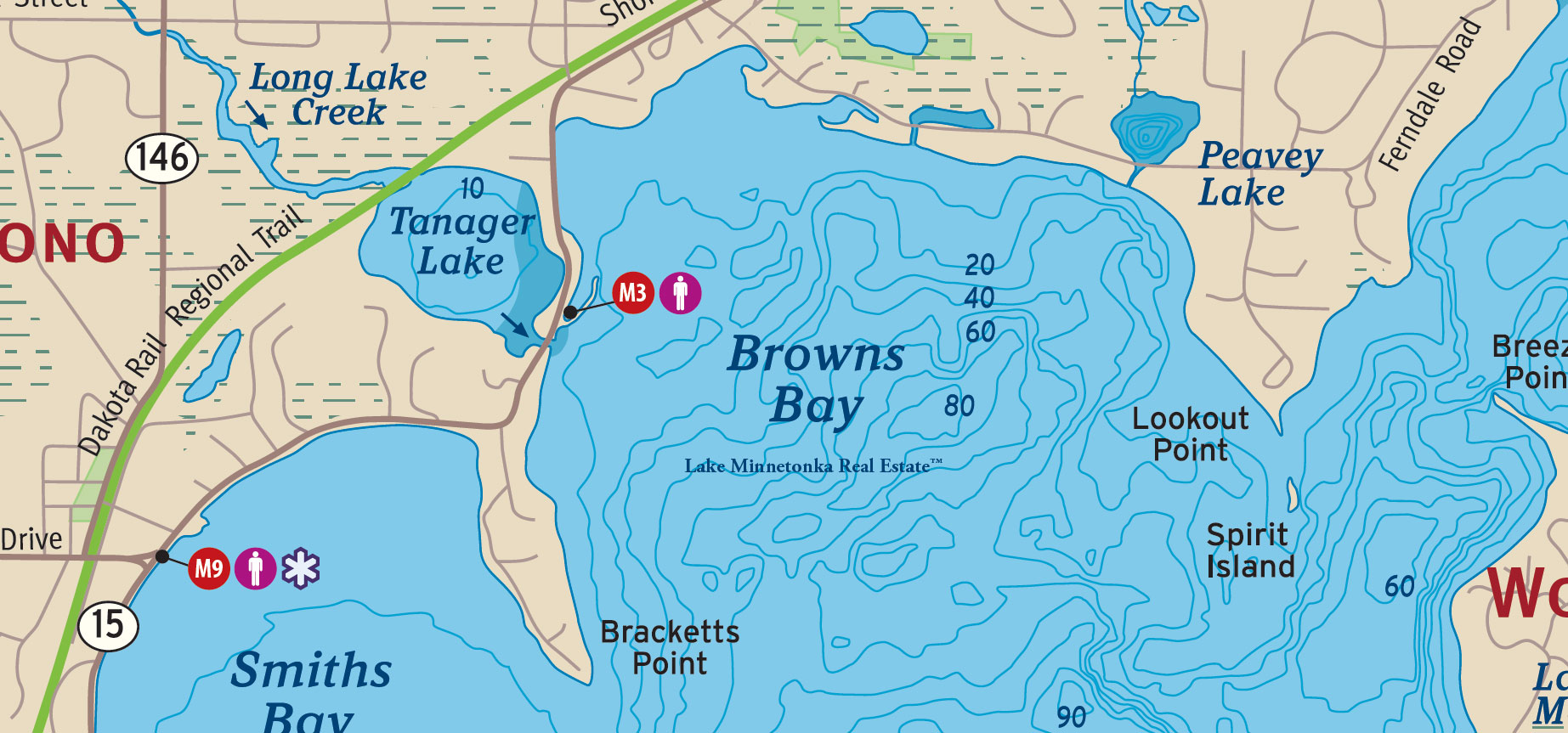
Its shoreline has a remarkable architectural history. Bracketts Point, named for former Minneapolis mayor George A. Brackett, was home to the celebrated Southways estate of the Pillsbury family, while Old Oaks, designed by William Channing Whitney, stands among the notable historic properties along the northern shore.
Historically awarded an A water-quality rating by the Minnehaha Creek Watershed District, Browns Bay is part of Lake Minnetonka's larger fishery, supporting musky, walleye, northern pike, bass, and panfish. Today, its wooded shoreline, established estates, and proximity to downtown Wayzata make it one of the Lower Lake's distinctive residential settings.
Black Lake
Black Lake, situated between Spring Park and Mound on the northwestern side of Lake Minnetonka, is one of the lake's smaller, more sheltered bodies of water. Bordered by Shoreline Drive to the north and Wilshire Boulevard to the east and south, Black Lake lies near Seton Lake, Emerald Lake, and Spring Park Bay, with Phelps Island just to the south.

In the early 1900s, guests staying at Maple Heights Inn on nearby Phelps Island enjoyed a landscape of summer cottages, rowboats, and water lilies. Women and children rowed among the abundant lilies of Black Lake, while bass fishing attracted anglers to the surrounding waters. The inn and its neighboring cottages were part of the summer resort development that preceded today's residential neighborhoods.
Encompassing approximately 80 acres, with 1.81 miles of shoreline and a maximum depth of 24 feet, Black Lake is relatively shallow, with approximately 80% of its waters classified as littoral habitat. Historically assigned a C water-quality rating, it remains popular with anglers pursuing crappies and panfish, from the shallow waters of spring and fall to the deeper fishing grounds of winter.
Carman Bay
Carman Bay, on the eastern side of Lake Minnetonka's Upper Lake, is bordered by Casco Point and Navarre, a neighborhood of Orono. To the east and south lie the Narrows, Old Channel Bay, and Locke Point, part of the interconnected waterways linking Lake Minnetonka's Upper and Lower Lake.
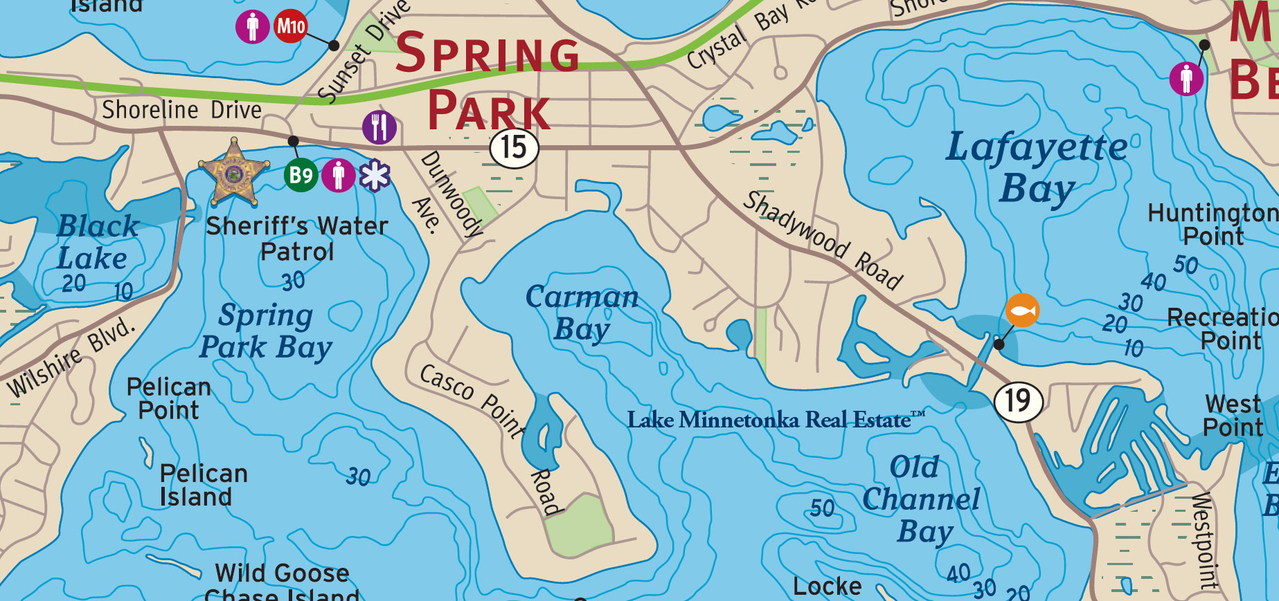
The bay takes its name from John Carman, a civil engineer from Ohio who arrived at Lake Minnetonka with his family in 1853. Carman surveyed and claimed extensive tracts of land around the lake, including portions of present-day Orono, Spring Park, and Navarre. The family initially lived in a two-room cabin on nearby Shady Island, and Carman's son-in-law, Mathias Cook, is remembered in the name of Cooks Bay. The family's history is closely connected to the earliest settlement of Lake Minnetonka's western shores.
Carman Bay encompasses approximately 403 acres, with 3.14 miles of shoreline and extensive shallow-water habitat covering roughly 46% of its surface area. Historically awarded an A water-quality rating, the bay is bordered by established residential neighborhoods and several notable landmarks, including Casco Point, Pelican Point, and Crescent Beach. Its location near the Narrows places it along one of the principal boating passages between Lake Minnetonka's Upper and Lower Lake.
Carsons Bay
Carsons Bay, along the Deephaven shoreline of Lake Minnetonka's Lower Lake, is a sheltered bay adjoining the historic neighborhood of Cottagewood. Fergusons Point lies to the west, while Grandview Point separates Carsons Bay from St. Louis Bay to the north. Nearby Swifts Point, Lighthouse Island, and Bug Island are among the landmarks that distinguish this part of Lake Minnetonka.
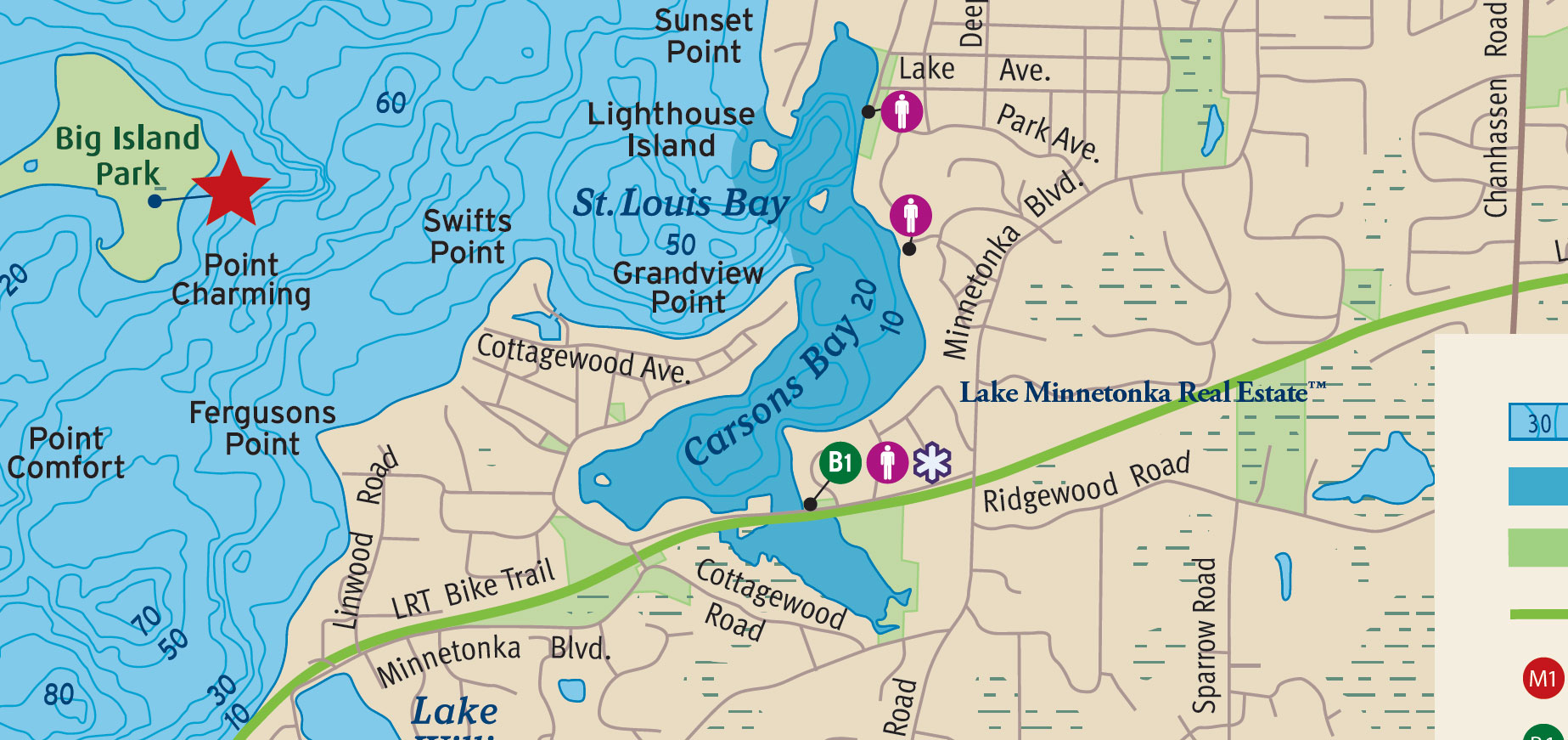
The bay takes its name from Elijah Carson, one of the earliest landowners in what became Deephaven. In 1878, Elijah and his wife, Mariah Carson, sold 108.55 acres to Victor Gibson, land that would become the site of the celebrated St. Louis Hotel. A decade later, Hazen and Alice Burton established their estate, Chimo, along the southern shore of Carsons Bay. Designed by architect William Channing Whitney, the residence became part of Deephaven's early history of sailing, summer estates, and the emerging Minnetonka Yacht Club. Burton would later become Deephaven's first mayor.
Encompassing approximately 173 acres, with 2.74 miles of shoreline and a maximum depth of 64 feet, Carsons Bay has substantial shallow-water habitat, with approximately 62% of its waters classified as littoral. Historically awarded an A water-quality rating, the bay has long provided protected anchorage along Deephaven's wooded shoreline. Its proximity to Cottagewood, St. Louis Bay, and the open waters of the Lower Lake remains one of its distinguishing characteristics.
Coffee Cove
Coffee Cove, along the Spring Park shoreline of Lake Minnetonka's West Arm, is tucked between Fagerness Point and Coffee Channel, which connects the West Arm to Crystal Bay. Deering Island lies just to the west, with Shadywood Point beyond it. Near the eastern end of the cove, Coffee Bridge and Lord Fletcher's Old Lake Lodge mark a familiar passage between two of Lake Minnetonka's distinctive bodies of water.
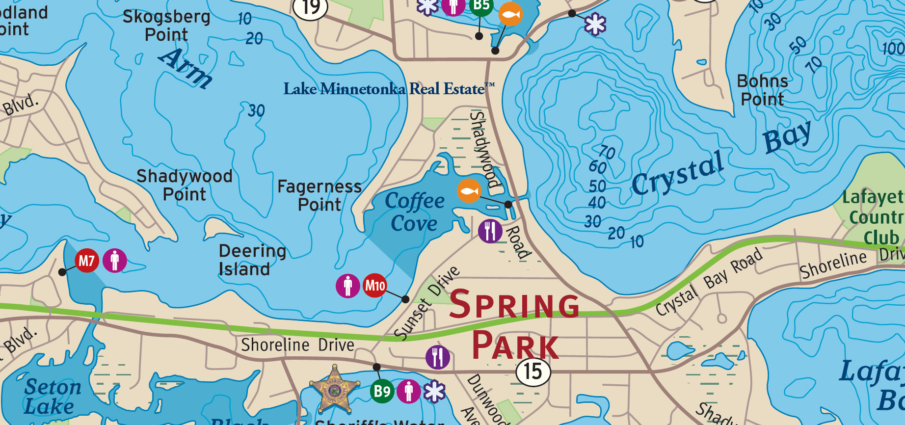
The Coffee name comes from Dr. Charles Curtis Coffee, a Minneapolis dentist, and his wife, Ginny Coffee, whose parents, Isaac and Lydia Webb, acquired land along the West Arm and Crystal Bay in the 1860s. Ginny inherited the property, where she and Charles established their summer retreat, Coffee Grounds. In 1903, the couple helped finance improvements to Coffee Bridge, which crossed the channel between the two bays. Their family name remains part of Lake Minnetonka's geography more than a century later.
Historically assigned a C water-quality rating, Coffee Cove occupies a relatively narrow portion of the West Arm. Its sheltered shoreline and connection through Coffee Channel to Crystal Bay give it a distinct setting within this part of Lake Minnetonka.
Cooks Bay
Cooks Bay, on the western side of Lake Minnetonka's Upper Lake, lies along the southern shoreline of Mound, between the city's Highlands neighborhood to the west and Phelps Island to the east. Covering approximately 550 acres, the bay extends south toward Hardscrabble Point, which separates it from neighboring Priests Bay. Along the northern shoreline, Bartlett Boulevard passes Surfside Park, a familiar gathering place with a history reaching back to Mound's resort era. The bay takes its name from Mathias Cook, son-in-law of John Carman, who established a log cabin overlooking the water in 1854 and later built the three-story Lake View Hotel in 1868.

By the late nineteenth century, Cooks Bay had become a popular summer destination, with hotels and boarding houses including Chapman House, Bartlett Place, Buena Vista Hotel, Hotel Kern, Hotel Dewey, and Sunset Villa. The Chapman House property would eventually give rise to one of Mound's best-remembered entertainment establishments. Hattie Chapman Taylor converted the former hotel boathouse into GlenIsle Casino, where visitors enjoyed dining, dancing, bowling, and other amusements. In the early 1960s, Bob and Joan Smeasteadt acquired the establishment and renamed it The Surfside. For the next two decades, Surfside was a popular destination for dining, live music, and evenings on the lake. Although the original establishment disappeared in the 1980s, its name lives on at Surfside Park and, since 2016, at Surfside Bar & Grill, a separate restaurant on Commerce Boulevard.
Today, Cooks Bay retains much of the residential character that developed as Mound's summer cottages and resort properties gradually gave way to year-round homes. The bay has a maximum depth of approximately 43 feet and has historically received a B water-quality rating. A public boat launch at Surfside Park provides access to the lake, while the historic Mound Depot, relocated to the park area in 1967, recalls an earlier era of travel and recreation. From its first settlers and lakeside hotels to the waterfront neighborhoods of today, Cooks Bay remains an important part of Mound's identity and the broader history of Lake Minnetonka.
Crystal Bay
Crystal Bay, on the northern side of Lake Minnetonka, lies between Orono and Minnetonka Beach, with Bohns Point, associated with St. Paul industrialist Gebhard Bohn, extending southward into the bay. Named by early settler Allen French for the remarkable clarity of its water, Crystal Bay reaches a maximum depth of approximately 113 feet, making it the deepest bay on Lake Minnetonka. Its historically assigned A water-quality rating is consistent with the clarity that first inspired its name.

The shoreline of Crystal Bay reflects an important chapter in Lake Minnetonka's history. In 1882, railroad magnate James J. Hill opened the grand Hotel Lafayette at Minnetonka Beach, overlooking the bay. Following the hotel's destruction by fire in 1897, the property became home to Lafayette Club, established in 1899 and still occupying much of the southern shoreline. To the north, Frederick and Josephine Noerenberg established their summer estate, Willkommen, in 1890, with landscaped grounds and gardens that would eventually become Noerenberg Memorial Gardens, preserved through the generosity of their daughter, Lora Noerenberg Hoppe. These properties are reminders of an era when prominent Minneapolis and St. Paul families built substantial summer residences along Lake Minnetonka.
At its western end, Crystal Bay connects with Coffee Cove and the West Arm through Coffee Channel and beneath Coffee Bridge, while another passage leads toward North Arm. The lake bottom descends sharply into deep water, with shallower weed flats and shoreline transitions providing varied habitat for walleye, bass, northern pike, muskellunge, crappie, and bluegill. Along Crystal Bay Road, Shoreline Drive, and the wooded shores surrounding Bohns Point, established homes occupy a setting shaped by the lake's unusually deep, clear water and a remarkable collection of historic properties.
East Upper Lake
East Upper Lake refers to the broad stretch of Lake Minnetonka between Casco Point to the north, Tonka Bay to the east, and Howard Point to the south. Spray Island, Shady Island, and Wild Goose Chase Island lie to the west, while Crescent Beach and Locke Point are among the landmarks along the eastern shoreline.
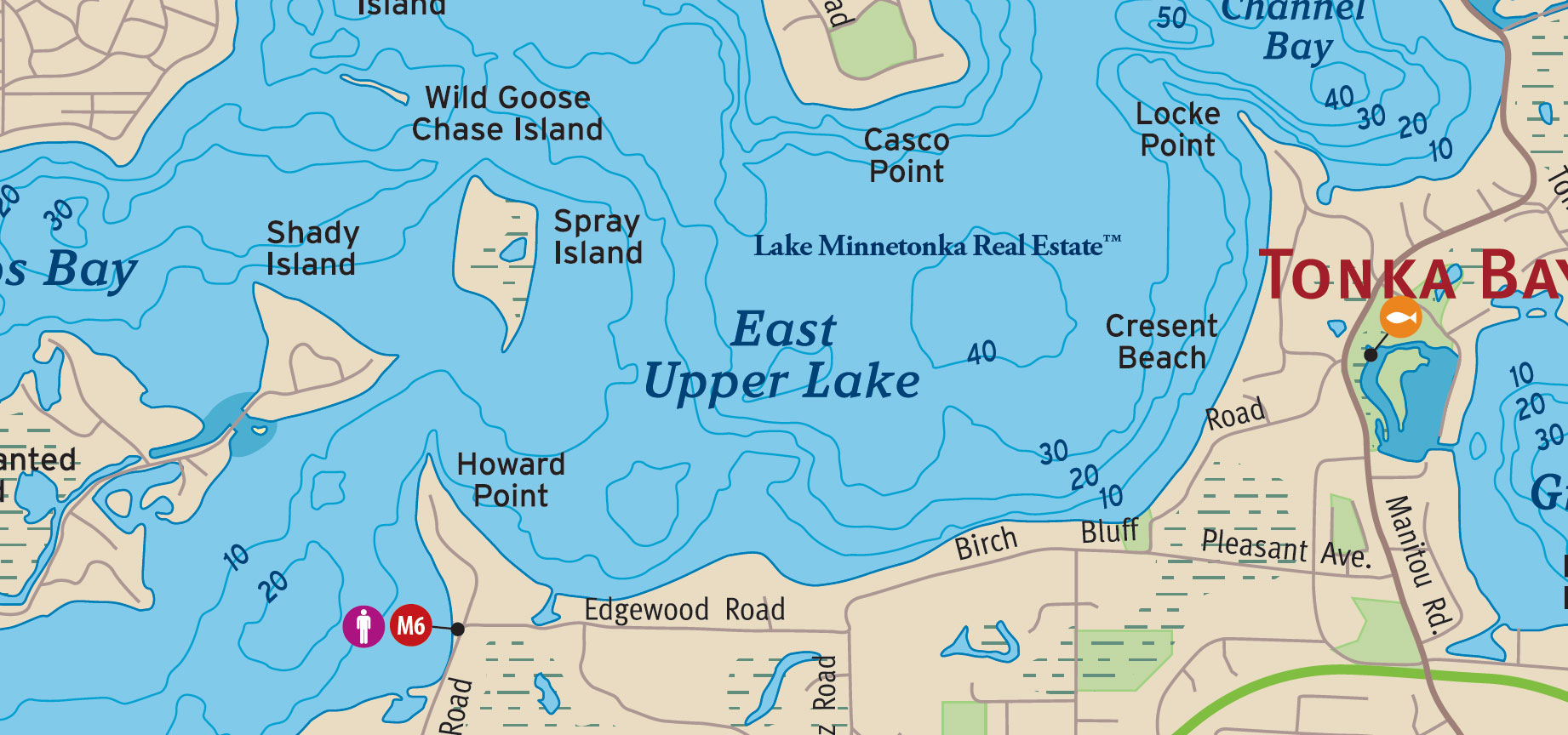
During the 1880s, Casco Point developed into a summer colony for prominent families from St. Paul and St. Louis. Visitors arrived by steamboat, and the colony maintained a clubhouse, guest accommodations, a French chef, and stables for approximately 50 horses. Summers were spent sailing, fishing, playing tennis, and riding horseback. Nearby Spray Island was once known as Hog Island.
Today, East Upper Lake provides access to Phelps Bay, Spring Park Bay, and the Narrows. Established homes line the shore along Crescent Beach, Birch Bluff, and Edgewood Road, where generations of residents have enjoyed the open water and wooded shoreline of the Upper Lake.
Echo Bay
Echo Bay lies between West Point in Tonka Bay and the western shoreline of Big Island, opening southward into Lower Lake South. Recreation Point, Huntington Point, and Mahpiyata Island lie to the north, while Gale Island is just beyond the bay to the southeast.

In 1879, Lake Park Hotel, the first of Lake Minnetonka's great resort hotels, opened on the Tonka Bay shoreline of Echo Bay, directly across from Big Island. Guests arrived by railroad to enjoy the lake, establishing a tradition of summer recreation that continues here nearly a century and a half later.
The hotel was eventually renamed the Tonka Bay Hotel, and by 1908 the Minnetonka Boat Club was operating next door. During the late 1920s or early 1930s, the property began its transition into what became Tonka Bay Marina.
Today, Tonka Bay Marina remains a familiar landmark on Echo Bay, serving generations of Lake Minnetonka boaters from a shoreline that has been associated with recreation and hospitality since the nineteenth century.
Emerald Lake
Emerald Lake is a small, sheltered body of water in Mound, situated between Seton Lake and Cooks Bay, near Phelps Island. The lake lies north of Wilshire Boulevard and south of Shoreline Drive, with Black Lake and Spring Park Bay to the east.
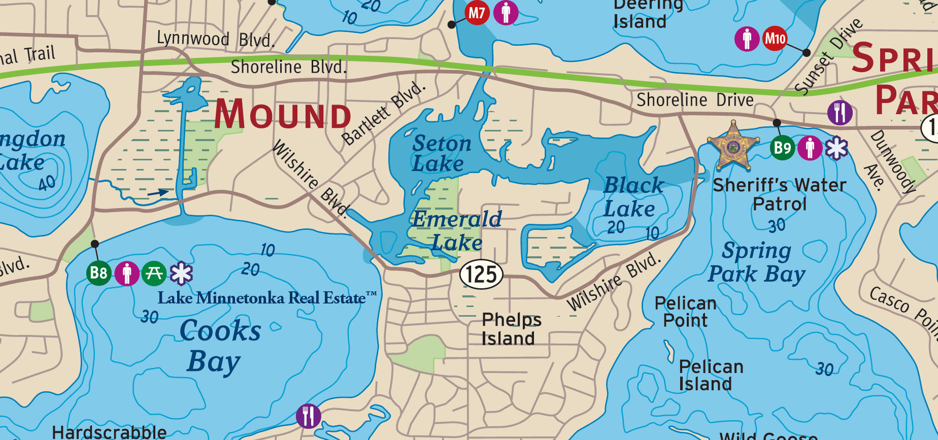
Covering approximately 15 acres, Emerald Lake has 1.02 miles of shoreline and a maximum depth of 16 feet, according to the Minnesota Department of Natural Resources. Approximately 93% of the lake is classified as littoral habitat, reflecting its predominantly shallow waters.
The Minnehaha Creek Watershed District has historically assigned Emerald Lake a C water-quality rating.
Excelsior Bay
Excelsior Bay lies along the northern waterfront of Excelsior, opening into Lower Lake South on Lake Minnetonka. Sunrise Point and Gideon Bay lie to the northwest, while Solberg Point marks the eastern side of the bay near St. Albans Bay. Along its southern shoreline are Excelsior Commons, Lake Street, and the historic downtown that has been a destination for lake visitors since the nineteenth century.
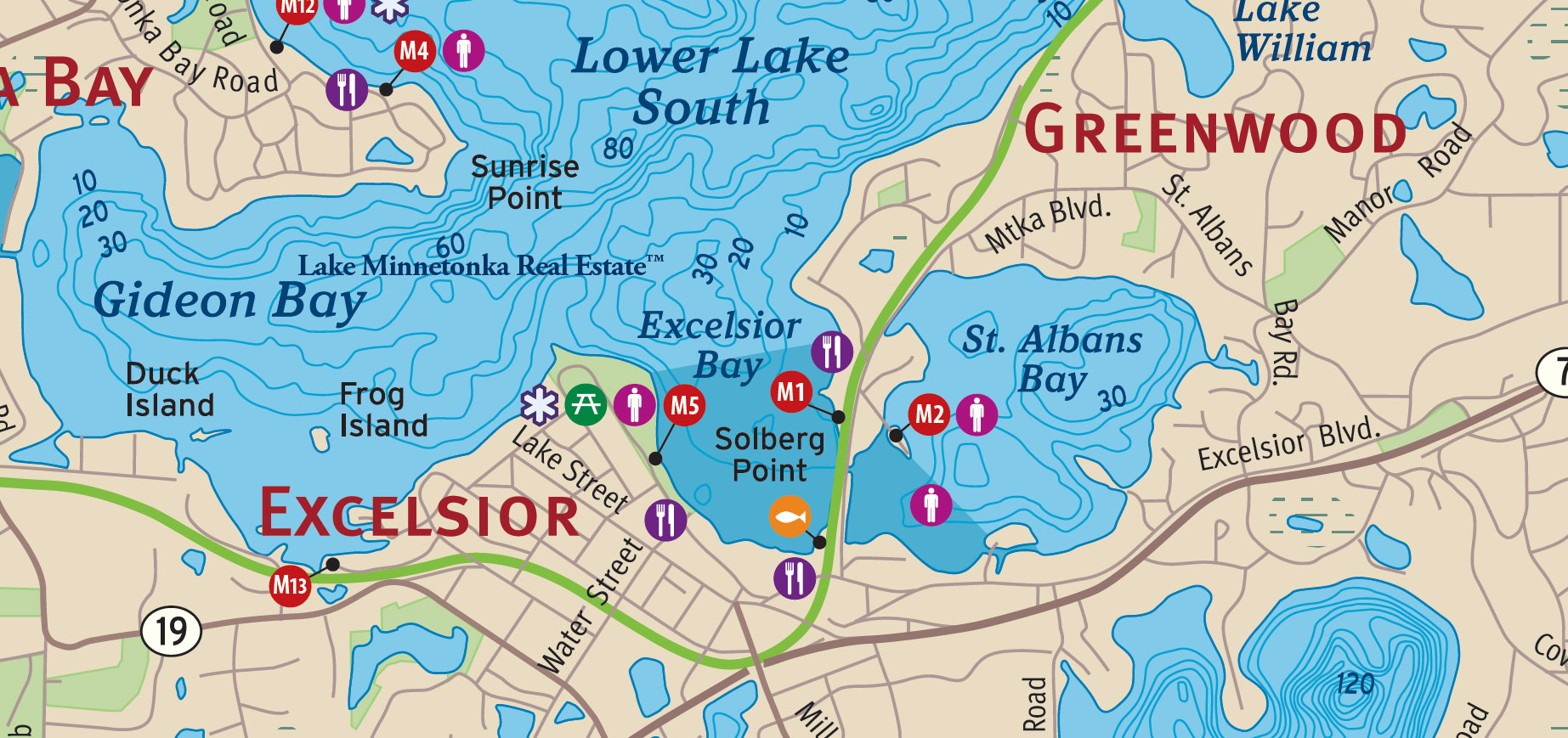
Founded in 1853, Excelsior was among the earliest settlements on Lake Minnetonka. In 1854, approximately 17 acres along the waterfront were set aside as Excelsior Commons, preserving public access to the lake. Around 1860, the Governor Ramsey, generally recognized as Lake Minnetonka's first steamboat, was launched near Excelsior's shoreline, beginning an era of commercial navigation and passenger excursions that would help establish the lake as a summer destination.
By the 1880s, Excelsior's waterfront had become a busy transportation center, where steamboats, excursion vessels, and railroad passengers converged. During the early twentieth century, that tradition continued with boatyards, public docks, and entertainment establishments, including Excelsior Amusement Park, which opened in 1925 and entertained generations of visitors before closing in the 1970s.
Today, Excelsior Commons, the public docks, and the shops and restaurants along Lake Street remain closely connected to life on the water. Excelsior Bay encompasses approximately 123 acres, with 1.14 miles of shoreline and a maximum depth of 34 feet. The bay has historically received an A water-quality rating.
Forest Lake
Forest Lake is a sheltered, 84-acre lake in Orono, situated north of Lake Minnetonka's West Arm and west of North Arm. North Shore Drive follows its western shoreline, while North Arm Drive runs to the east. At its southern end, a narrow channel connects Forest Lake to the West Arm near Skogsberg Point.
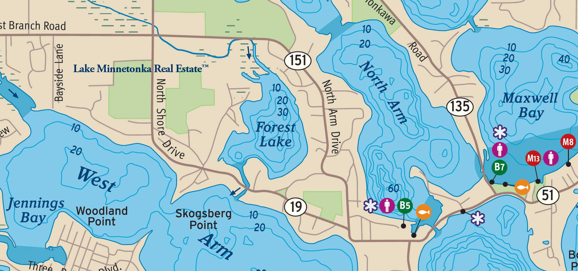
Forest Lake takes its name from the heavily wooded shoreline that once surrounded it. Originally a separate body of water, the lake was connected to Lake Minnetonka when a channel was dredged during the mid-nineteenth century. That passage remains an important feature of Forest Lake's geography, providing access to the larger lake while preserving its relatively secluded setting.
Forest Lake encompasses approximately 84 acres, with 1.72 miles of shoreline and a maximum depth of 42 feet. Approximately 58% of its waters are classified as littoral habitat, supporting aquatic vegetation and shallow-water fish habitat. The lake has historically received a C water-quality rating.
Gideon Bay
Gideon Bay lies along the southern shore of Lake Minnetonka's Lower Lake, between Tonka Bay and Excelsior. Sunrise Point marks the northeastern entrance to the bay, while Duck Island and Frog Island lie within its waters. To the east, the shoreline continues toward Excelsior Bay.
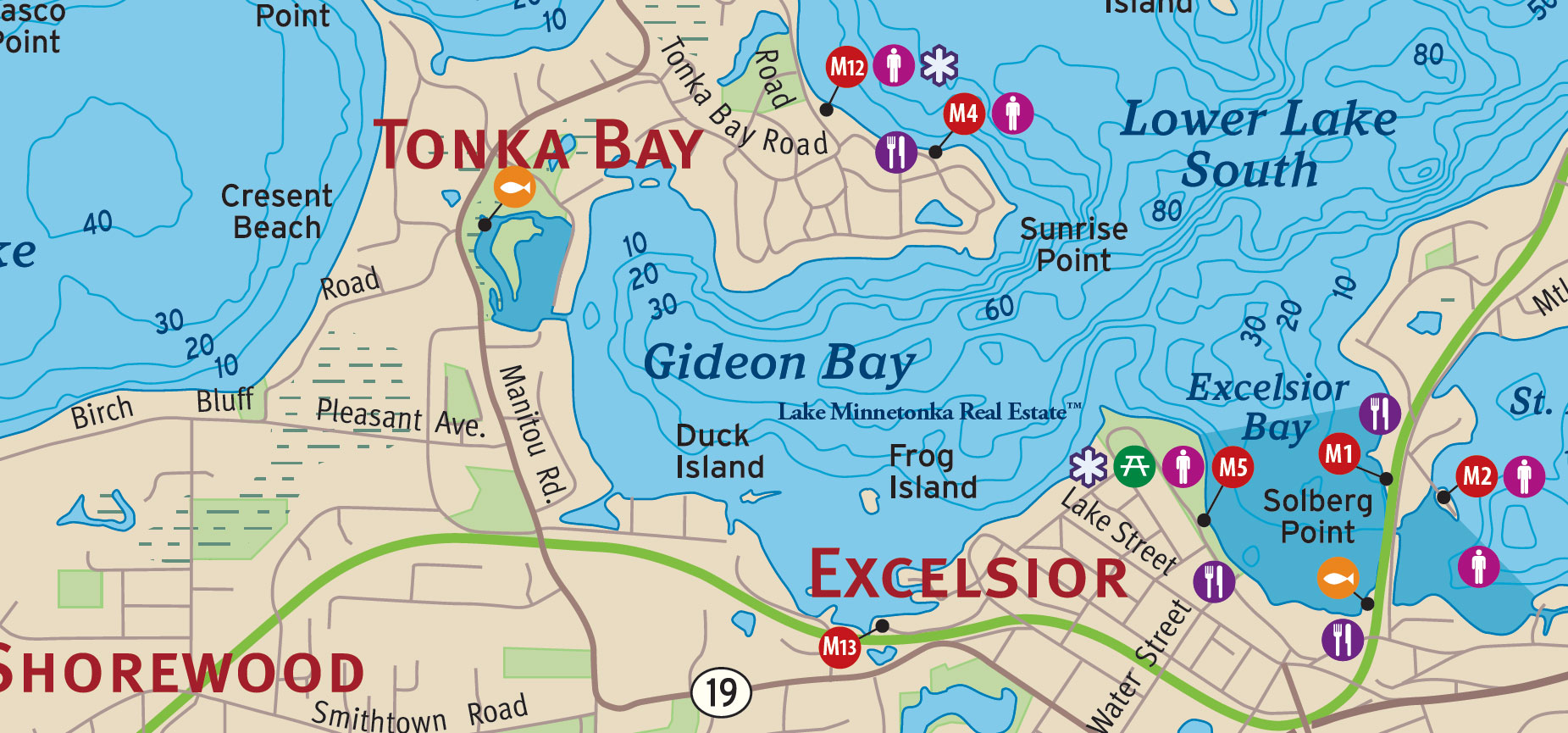
The bay takes its name from Peter M. Gideon, who settled on approximately 160 acres along its southern shore in 1853. An abolitionist and pioneering horticulturist, Gideon devoted much of his life to developing fruit trees capable of surviving Minnesota's severe winters. After years of experimentation and considerable hardship, he introduced the Wealthy apple in 1864, naming it for his wife, Wealthy Hull Gideon. The apple became an important contribution to fruit growing in northern climates.
Gideon's work eventually attracted the attention of the State of Minnesota, which established an experimental fruit farm adjoining his property in 1878 and appointed him its superintendent. Today, Gideon Bay encompasses approximately 350 acres, with 3.14 miles of shoreline and a maximum depth of 56 feet. Its historical A water-quality rating, established residential shoreline, and proximity to Excelsior distinguish this portion of Lake Minnetonka.
Grays Bay
Grays Bay occupies the eastern end of Lake Minnetonka, bordered by Wayzata, Woodland, and Minnetonka. Situated east of Wayzata Bay, it is particularly significant as the lake's outlet into Minnehaha Creek, which flows approximately 22 miles eastward to the Mississippi River.

In 1822, Joseph R. Brown and companions from Fort Snelling traveled upstream along Minnehaha Creek and reached Lake Minnetonka through what is now Grays Bay. The journey was among the earliest recorded European-American expeditions to the lake. The bay later took its name from Amos N. Gray, whose family settled in the area during the 1850s, when farming communities began developing along the eastern shores of Lake Minnetonka.
The movement of water through Grays Bay has shaped the history of the lake well beyond its immediate shoreline. Following earlier attempts to regulate the outlet, the modern Grays Bay Dam was constructed in 1979, establishing the principal structure used to manage water flowing from Lake Minnetonka into Minnehaha Creek. Today, the bay encompasses approximately 175 acres, with 2.19 miles of shoreline and a maximum depth of 28 feet. It has historically received an A water-quality rating.
Halsted Bay
Halsted Bay occupies the westernmost reaches of Lake Minnetonka in Minnetrista, where Six Mile Creek enters the lake. Westedge Boulevard separates it from neighboring Priests Bay, while Rocky Reef lies farther east in West Upper Lake. The shoreline was once part of a landscape of farms and wooded homesteads.
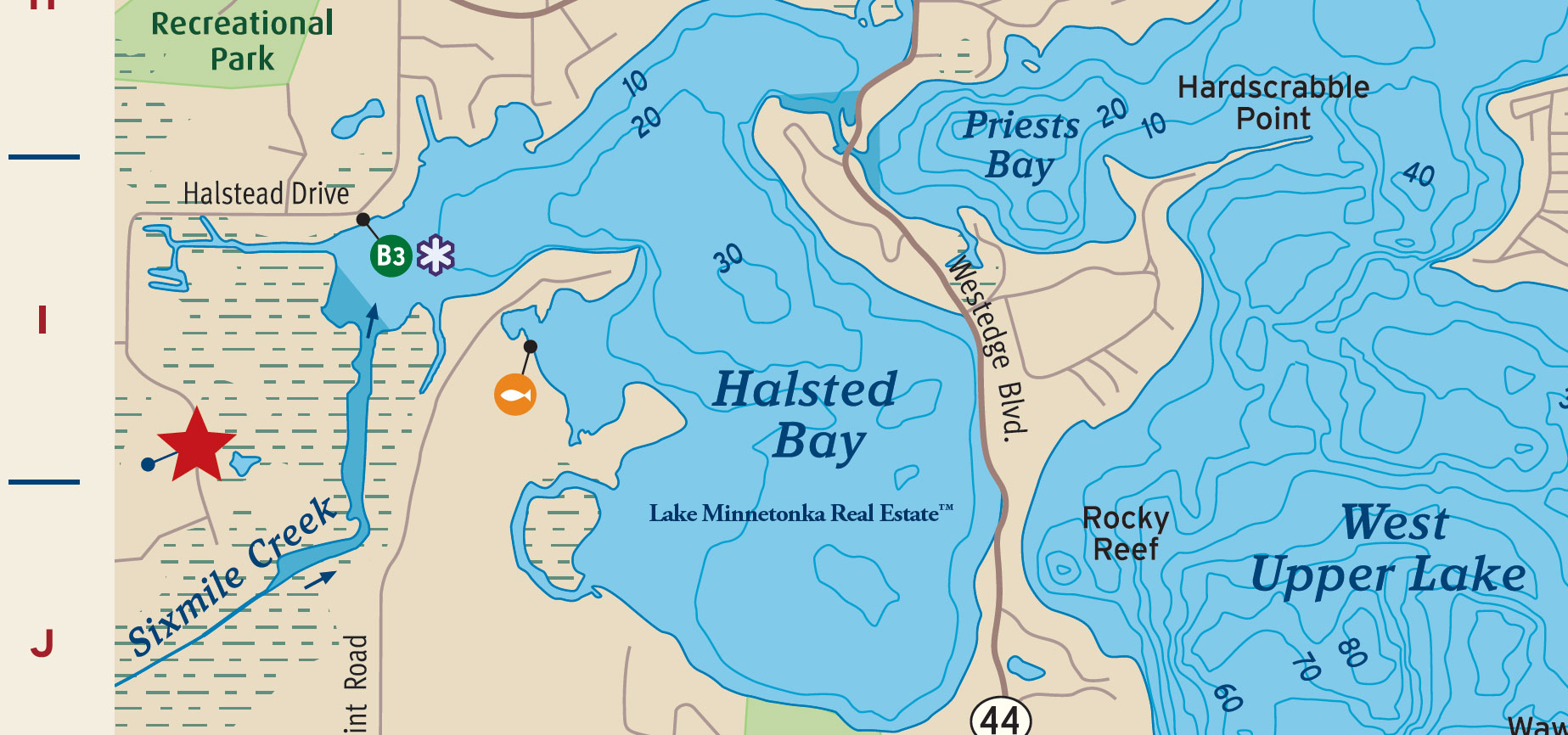
The bay takes its name from Captain Frank W. Halstead and his brother, Major George B. Halstead, known in local histories as the Hermits of Minnetonka. Frank settled here in 1855, initially building a cabin called Rough and Ready. He became Minnetrista's first justice of the peace and participated in the christening of the Governor Ramsey, Lake Minnetonka's first steamboat. After serving in the Civil War, he built the Hermitage, a larger home overlooking Crane Island.
In 1876, Frank commissioned the steamer Mary, named for his mother. Following Frank's death that summer, George came to settle his affairs, remained on the lake, and completed the vessel. The Mary suffered a boiler explosion in 1880 and was later rebuilt. George continued to welcome excursionists at the Hermitage until he died when the house burned in 1901. The following year, C. M. Loring acquired the property for his Woodend dairy farm.
Harrison's Bay
Harrison's Bay lies along the northern shoreline of Mound, between Jennings Bay and West Arm on the northwestern side of Lake Minnetonka. The bay takes its name from Captain Nathaniel Harrison, an early settler and shipwright from Virginia who acquired property along its northern shore in 1855. The surrounding shoreline was among the areas settled during the earliest years of Minnetrista Township.
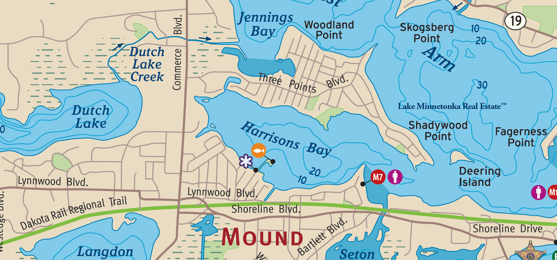
Harrison became an important figure in Lake Minnetonka's early steamboat industry. Between 1874 and 1880, he designed and built vessels that carried passengers between the lake's growing settlements and summer destinations. Among his better-known designs were the May Queen, built in 1873 for Captain William Rockwell, and the Mary, commissioned by Captain Frank Halstead and subsequently operated by his brother Major George Halstead. Harrison also designed the Minneapolis, launched in 1880. These vessels were part of a remarkable period when much of the lake's transportation depended on locally built boats.
Today, Harrison's Bay encompasses approximately 211 acres, with 3.61 miles of shoreline and a maximum depth of 46 feet. Its historical C water-quality rating reflects the conditions of this northwestern portion of Lake Minnetonka.
Jennings Bay
Jennings Bay lies along the northwestern shoreline of Lake Minnetonka, north of the Three Points neighborhood in Mound. Woodland Point separates the bay from the eastern reaches of West Arm, while Dutch Lake Creek enters from the west. Harrison's Bay lies south of Three Points, placing the peninsula between two of Lake Minnetonka's historically named bays.

The bay takes its name from Frederick A. Jennings, who was born in London, England, in 1807 and emigrated to America as a young man. Before settling on Lake Minnetonka, Jennings worked in the iron industry near Philadelphia, where he operated a rolling mill, and later pursued mercantile and freight businesses in Pennsylvania. His family established a farm on Jennings Bay in 1855, and he joined them in 1857. From 1861 to 1877, Jennings worked for the United States Treasury Department in Washington, D.C., before returning to his Minnesota property.
The Jennings family remained connected to the development of Mound, contributing timber for the construction of Bethel Methodist Episcopal Church in the early 1890s. Today, Jennings Bay encompasses approximately 285 acres, with 3.05 miles of shoreline and a maximum depth of 23 feet.
Lafayette Bay
Lafayette Bay lies along the shoreline of Minnetonka Beach, west of Huntington Point and near the historic Lafayette Club. Originally known as Holmes Bay, it occupies a distinctive position between the northern waters of Lake Minnetonka's Lower Lake and neighboring Crystal Bay, an area closely associated with the lake's great nineteenth-century resorts.
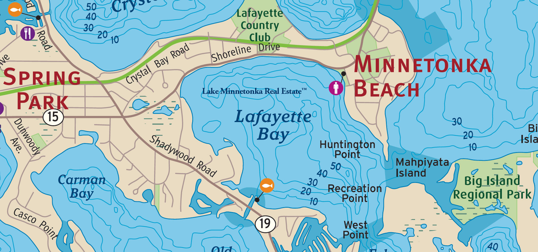
The bay acquired its present name from the Hotel Lafayette, built by railroad magnate James J. Hill and opened on July 2, 1882. With approximately 300 guest rooms overlooking both Crystal Bay and Lafayette Bay, the hotel was among the largest and most elaborate summer resorts in the country. Hill built the hotel to attract passengers to his railroad, and its opening coincided with the arrival of the enormous steamboat Belle of Minnetonka, capable of carrying 2,500 passengers. In 1883, the Lafayette entertained President Chester A. Arthur and other distinguished visitors.
Hill also established a nearby dairy farm, raising imported cattle to supply the hotel. The Lafayette continued operating through the summer of 1897, but was destroyed by fire on October 4 of that year. The hotel was never rebuilt, although its name survived in Lafayette Bay and the nearby Lafayette Club. Today, the bay encompasses approximately 460 acres, with 3.47 miles of shoreline and a maximum depth of 62 feet.
Libbs Lake
Libbs Lake lies southeast of Grays Bay, at the eastern end of Lake Minnetonka in the city of Minnetonka. Surrounded by residential neighborhoods, the small lake is connected to Grays Bay by a narrow channel near Grays Bay Boulevard. The Minnehaha Creek headwaters lie just to the northeast, with Jidana Park and Lake Shore Boulevard along its eastern shoreline.

The lake takes its name from Elizabeth "Lib" Ogin, whose family was among the early settlers of this part of Minnetonka. Elizabeth came to the area to care for her unmarried brother, Henry Ogin, and later married and raised two children. The lake was named for her in 1890, preserving a personal connection to the families who established farms and homesteads around the eastern end of Lake Minnetonka during the nineteenth century.
Originally separate from Grays Bay, Libbs Lake became part of Lake Minnetonka's connected waters when a channel was dredged during the 1800s. That modest engineering project gave the small lake an outlet to the much larger body of water to its west. Today, Libbs Lake encompasses approximately 23 acres, with 1.11 miles of shoreline and a maximum depth of 8 feet. Its historical water-quality classification is B.
Lost Lake
Lost Lake lies within the marshland of Mound, north of Cooks Bay and just south of the former railroad corridor now occupied by the Dakota Rail Regional Trail. Langdon Lake lies to the west, with Seton Lake and Emerald Lake farther east. Although modest in size and surrounded by wetlands, Lost Lake became the focus of an ambitious transportation project in 1906, when local residents sought to connect Mound's railroad depot with the steamboat traffic on Lake Minnetonka.
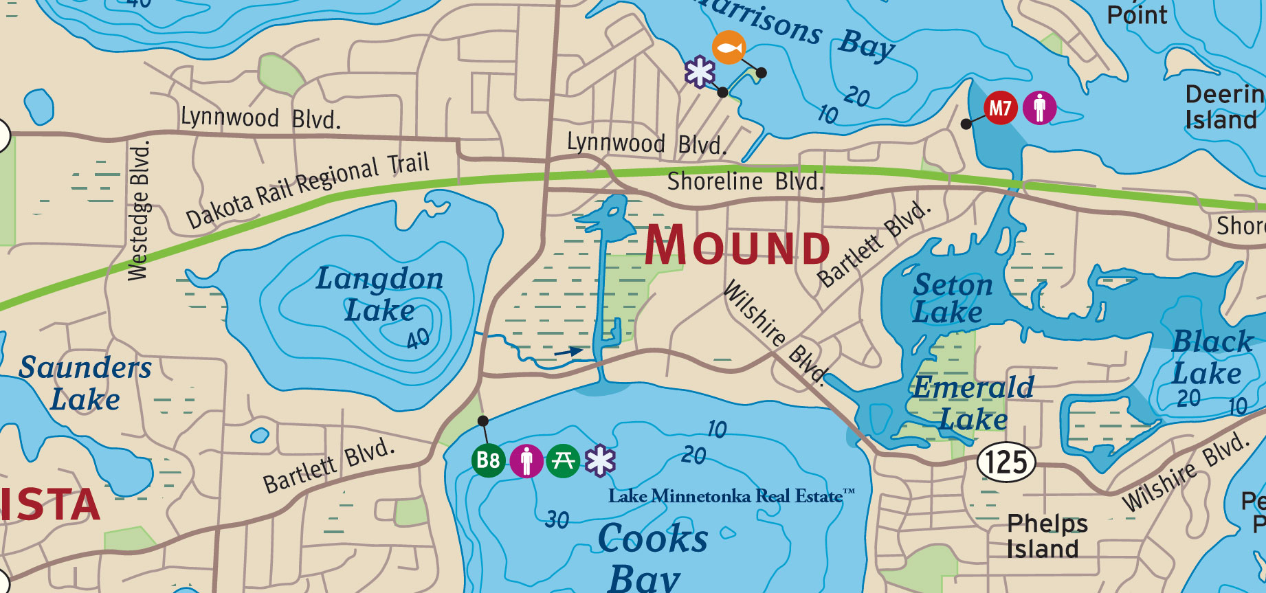
In 1906, local residents petitioned for a canal connecting the Mound railroad depot with Cooks Bay, eliminating the need for passengers to travel by horse-drawn wagon between the station and the steamboat docks. County officials approved the project, and a 30-foot-wide canal was excavated through the marsh at a cost of approximately $3,000. The passage opened on October 5, 1906, when Fred Bartlett made the inaugural trip aboard his steamboat, the Mound.
The canal proved difficult to maintain. Excavated through the soft ground of Lost Lake without adequate reinforcement, its banks deteriorated and mud accumulated in the channel. Repeated dredging became costly, and improvements in road transportation eventually made the passage unnecessary. Much of the canal disappeared during subsequent development, although its history remains part of Mound's early waterfront story.
The surrounding wetlands still support cattails and reeds, providing natural filtration for runoff entering Lake Minnetonka. Lost Lake reaches a maximum depth of approximately 3 feet and has historically received a C water-quality rating.
Lower Lake North
Lower Lake North encompasses a broad expanse of open water on Lake Minnetonka, stretching eastward from Smiths Bay toward Robinsons Bay and the shoreline of Woodland. Bracketts Point marks part of its northern boundary, while Big Island lies to the south. Along the eastern shore, Gibsons Point and Sunset Point lead toward Lighthouse Island, with the wooded shoreline of Deephaven beyond.

These waters were once among the principal routes traveled by Lake Minnetonka's passenger steamers. During the late nineteenth century, boats crossed the Lower Lake carrying guests between railroad landings, grand hotels, and the summer cottages appearing along its shores. The communities of Minnetonka Beach, Woodland, and Deephaven retain much of the geographic character established during that period, even as successive generations have built and rebuilt their lakeside homes.
Unlike the smaller, sheltered bays, Lower Lake North is defined by considerable depth and broad stretches of uninterrupted water. The eastern portion reaches approximately 96 feet, making it one of the deeper areas of Lake Minnetonka. Its exposed shoreline and expansive views have long distinguished this part of the lake, where the relationship between the open water, wooded points, and neighboring islands is particularly apparent.
Lower Lake South
Lower Lake South occupies one of the great stretches of open water on Lake Minnetonka, bordered by Tonka Bay to the west and Greenwood to the east. Gale Island lies toward its northern reaches, with Crown Point and Point Comfort beyond. Along the southern shoreline, Sunrise Point extends into the lake, while the waters open toward Excelsior Bay and Gideon Bay. To the northwest, Echo Bay recalls an earlier chapter in Lake Minnetonka's resort history.

During the late nineteenth century, these waters were familiar to passengers aboard the steamboats that connected the lake's growing summer communities. The Lake Park Hotel, established on Echo Bay in 1879, was among the earliest of Lake Minnetonka's celebrated resort hotels. Its guests, along with visitors bound for Excelsior and the surrounding shores, traveled a lake whose network of steamers and landings made its more distant destinations accessible well before modern roads.
The southern Lower Lake remains one of the lake's more expansive and distinctive bodies of water. Its depth reaches approximately 77 feet, with steep underwater contours near Greenwood and the points extending from the western shoreline. The basin encompasses approximately 1,069 acres and 7.53 miles of shoreline. Here, the contrast between the open water, wooded points, and more sheltered adjoining bays is especially apparent.
Maxwell Bay
Maxwell Bay lies along the northern reaches of Lake Minnetonka in Orono, east of North Arm and south of Stubbs Bay. North Shore Drive follows the southeastern shoreline, where the grounds of Noerenberg Memorial Gardens extend toward the water. Beyond the bay to the northeast lie the wetlands surrounding French Lake, while the western approaches lead toward Crystal Bay.
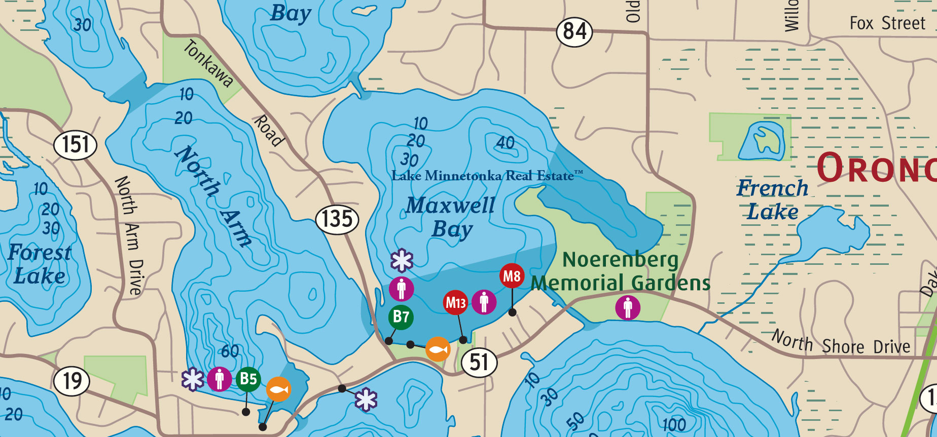
The bay takes its name from John Maxwell, a Scottish immigrant who settled along its northeastern shore around 1854. Maxwell had served as a military fifer, and local accounts remember him rowing across the water while playing his instrument, the music reportedly carrying for considerable distances over the lake. He died in 1858, but his name has remained attached to this quiet northern bay for more than a century and a half.
Another important chapter began in 1890, when Frederick and Johanna Noerenberg acquired approximately 73 acres of lakeshore and established an estate called Wilkommen, meaning welcome. Frederick, a prominent figure in the Minneapolis brewing industry, developed the property with a substantial residence, formal gardens, and a working farm. Their daughter, Lora Noerenberg Hoppe, later arranged for the property to be preserved for public enjoyment. Today, Noerenberg Memorial Gardens remains one of the finest surviving landscapes from Lake Minnetonka's estate era.
Maxwell Bay encompasses approximately 300 acres, with 3.43 miles of shoreline and a maximum depth of approximately 44 feet.
North Arm
North Arm is one of the more distinctive northern extensions of Lake Minnetonka, reaching into Orono between North Arm Drive and Tonkawa Road. Forest Lake lies to the west, while Maxwell Bay and Stubbs Bay occupy the waters farther east. At its southern end, North Arm opens toward Crystal Bay, where the narrow, sheltered shoreline gives way to considerably broader water.

Originally known as Haines Bay, North Arm took its earlier name from the Haines family, who settled along its western shore during the nineteenth century. In 1855, newspaperman William Russell established a post office called Tazaska, or Island City, on the western shore. The settlement was associated with an unsuccessful effort to establish Minnesota's state capital in this part of the lake country. The post office closed in 1860, and the name Haines Bay eventually gave way to North Arm, which was in use before 1888.
The surrounding shoreline retains connections to Orono's earliest settlement period. Farms and homesteads gradually gave way to lakeside residences, while the narrow passages and wooded banks continued to distinguish North Arm from the more open waters of the lake. The Boy Scout Bridge, between North Arm and Maxwell Bay, also recalls a former scouting camp in the vicinity.
North Arm encompasses approximately 307 acres, with 4.57 miles of shoreline and a maximum depth of 64 feet.
Old Channel Bay
Old Channel Bay lies along the northern shoreline of Tonka Bay, between Casco Point and the peninsula separating it from Echo Bay. Carman Bay occupies the waters to the northwest, while Locke Point extends into the bay from the south. This part of Lake Minnetonka preserves an important chapter in the history of navigation between the Upper Lake and Lower Lake.
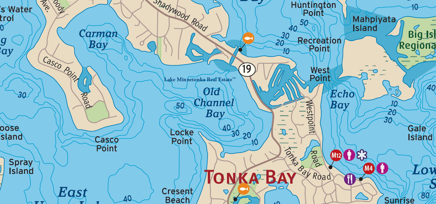
Before the present Narrows Channel became the principal passage between the lake's two great bodies of water, travelers used a narrower waterway known as Hull's Narrows, named for Reverend Stephen Hull, an early settler who owned property beside the channel. Originally little more than a creek, the passage was dredged and widened in 1873, allowing steamboats such as the Governor Ramsey to travel between the Upper and Lower Lake. As steamboat traffic increased and larger vessels entered service, the limitations of the original passage became increasingly apparent.
The development of a more accommodating route eventually gave the older waterway its familiar name, Old Channel Bay. Portions of the original channel were subsequently altered or filled, including work associated with the passage of Shadywood Road, now Highway 19. The name remains a reminder of the period when even a relatively narrow channel could determine how people traveled, where settlements developed, and which parts of the lake became accessible.
Old Channel Bay is also historically associated with Carman Bay, a neighboring name that has sometimes been used for the same general waters.
Peavey Lake
Peavey Lake lies just west of Ferndale Road in Wayzata, between Browns Bay and Wayzata Bay on Lake Minnetonka. Sometimes called Peavey Pond, this small lake is connected to Browns Bay by a narrow channel beneath Ferndale Road. Although modest in surface area, its considerable depth distinguishes it from the shallow ponds and wetlands found elsewhere around the lake.

The lake takes its name from Frank H. Peavey, a prominent Minneapolis grain merchant whose Highcroft estate became one of the notable country properties along Wayzata's Ferndale shore. Developed during the 1890s, the estate occupied approximately 110 acres, with an imposing brick residence, landscaped grounds, and a working dairy farm. Peavey was also a friend of railroad magnate James J. Hill, who arranged for a railroad stop at Ferndale, providing convenient access to the estate from Minneapolis.
The Highcroft residence stood from 1895 until 1953, but its history remains part of the story of the great estates that once characterized this stretch of Lake Minnetonka. Peavey Lake itself encompasses approximately 9 acres, with 0.57 miles of shoreline. Despite its small size, the lake reaches a reported maximum depth of approximately 63 feet. Its narrow channel provides a connection to Browns Bay, although access is constrained by the passage beneath Ferndale Road.
Phelps Bay
Phelps Bay lies in the Upper Lake portion of Lake Minnetonka, bordered by Phelps Island to the north and Enchanted Island to the south. Shady Island and Spray Island lie farther east, while the waters open southwest toward West Upper Lake. The bay is part of an intricate shoreline of islands, wooded points, and narrow passages that has long distinguished this part of Lake Minnetonka.
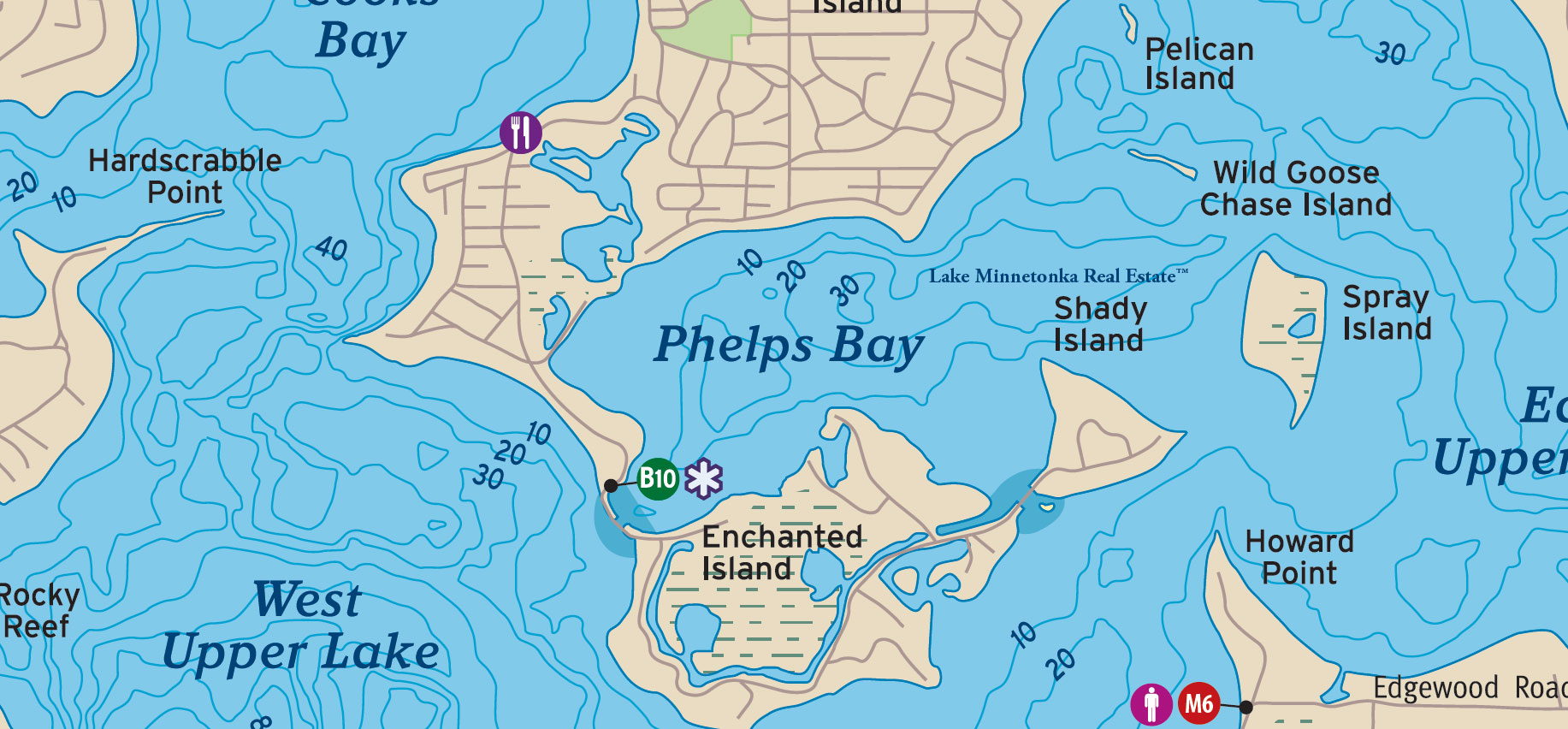
The bay takes its name from Carrington Phelps, who, with his wife Catherine, acquired property on what was then known as Noble's Island in 1875. Two years later, the family established a summer residence called Phelps Lodge. The island had originally been connected to the mainland as a peninsula, but nineteenth-century channel improvements gradually altered its relationship to the surrounding waters. By 1891, Carrington was advertising portions of the property for summer cottages, reflecting the growing demand for lakeshore retreats.
A 1906 tornado dramatically changed the landscape of Phelps Island and its neighbors, including Enchanted Island and Shady Island. The destruction of much of the original timber was followed by additional subdivision and cottage construction, helping establish the residential character that remains today.
Phelps Bay encompasses approximately 379 acres, with 3.81 miles of shoreline and a maximum depth of 36 feet.
Priests Bay
Priests Bay lies in the western reaches of Lake Minnetonka, between Halsted Bay and Cooks Bay, along the shoreline of Minnetrista. Hardscrabble Point extends into the water from the east, while Westedge Boulevard crosses the narrow passage leading toward Halsted Bay. The surrounding shoreline reflects an earlier landscape of farms and homesteads, established when this part of the lake was still relatively remote from its principal settlements.
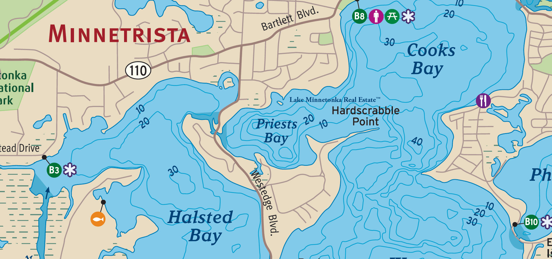
The bay takes its name from the Priest family, who owned farmland along its northern shore during the nineteenth century. Historical accounts identify a landowner named J. D. Priest in the area by 1876, while other local records describe a substantial farm acquired by Darwin Priest in 1878. The name survives as a reminder of the agricultural families whose properties preceded much of the lakeshore development seen today.
In 1880, the narrow channel leading west toward Halsted Bay was dredged and widened to accommodate steamboat traffic. The improvements made the far western waters of Lake Minnetonka more accessible at a time when travel by boat was central to commerce, settlement, and summer recreation. The passage remains one of the geographic features that distinguishes Priests Bay from its neighbors.
Today, Priests Bay encompasses approximately 138 acres, with 1.75 miles of shoreline and a maximum depth of 34 feet.
Robinsons Bay
Robinsons Bay lies along the eastern shore of Lake Minnetonka's Lower Lake, between Woodland and Deephaven. Gibsons Point marks its southwestern entrance, while Northome Boulevard follows the southern shoreline. Inland, Lake Marion and Shaver Lake recall the families and early settlements that shaped this part of the lake.
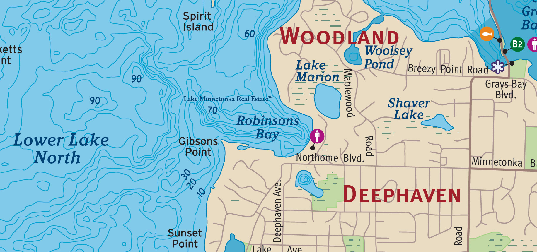
The bay takes its name from Alfred B. Robinson, who arrived in Minnesota in 1842 and worked at Fort Snelling before settling along Lake Minnetonka in 1853. Robinson became one of the early justices of the peace associated with Wayzata and established a farm near the bay. His wife is remembered in local accounts for assisting at the birth of twins Baynard and Bernard Shaver, among the area's earliest recorded births.
The neighboring shoreline became associated with Charles S. Gibson, a prominent St. Louis attorney who acquired property here in 1870. In 1877, Gibson built Northome, an imposing summer residence overlooking the Lower Lake. The estate gave its name to Northome Boulevard, while Gibsons Point preserves the family's connection to the waterfront. This was part of the period when the wooded shorelines of Woodland and Deephaven began attracting substantial summer homes alongside the earlier farms and cottages.
Robinsons Bay encompasses approximately 90 acres, with 0.86 miles of shoreline and a maximum depth of 70 feet.
Seton Lake
Seton Lake occupies a sheltered portion of Lake Minnetonka in Mound, immediately north of Emerald Lake and west of Black Lake. Shoreline Boulevard follows the northern side of this interconnected waterway, while Cooks Bay lies to the southwest and Spring Park Bay to the east. Although small in comparison with the lake's principal bays, Seton Lake belongs to a network of narrow channels that has long connected the surrounding waters.
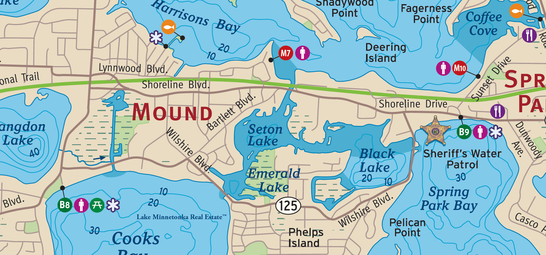
The lake takes its name from Seton Guild, an all-girls Catholic school and summer home that once occupied property along its shoreline. The institution honored Elizabeth Ann Seton, whose work in American Catholic education made her an important figure in the country's religious history. The name survives on the lake, although the school itself is no longer part of the surrounding neighborhood.
Seton Lake's history is also tied to the development of the channels connecting the smaller lakes around Mound and Spring Park. Dredging and improvements to these passages allowed boats to travel between Emerald Lake, Seton Lake, and Black Lake, creating a sheltered alternative to the more open waters nearby. The channels remain an interesting feature of this part of Lake Minnetonka, where the shoreline changes from established neighborhoods to wetlands and quiet, protected water.
Seton Lake encompasses approximately 44 acres, with 1.24 miles of shoreline and a maximum depth of 24 feet.
Smiths Bay
Smiths Bay lies along the northern edge of Lake Minnetonka's Lower Lake, between Minnetonka Beach and Orono. Bracketts Point defines its eastern entrance, where the sheltered waters open toward Lower Lake North. To the west, the narrow strip of land carrying County Road 15 separates the bay from Crystal Bay, while Browns Bay lies beyond the shoreline to the northeast.
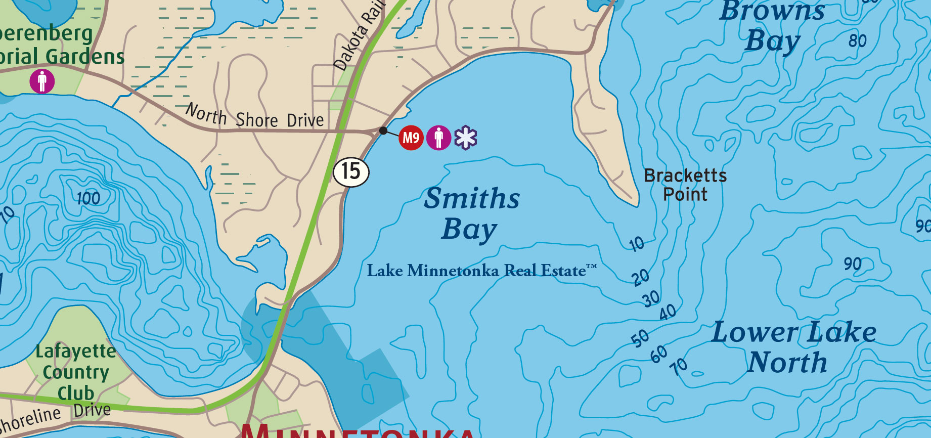
The bay takes its name from Elliot Smith, an early settler associated with this part of Lake Minnetonka. During the nineteenth century, the surrounding shoreline gradually changed from wooded land and early homesteads to summer residences and substantial lakeside estates. North Shore Drive followed the northern shoreline, connecting properties that once depended far more heavily on travel by water.
Neighboring Bracketts Point became one of the notable residential settings on the Lower Lake, later home to the celebrated Southways estate, whose history spans the Brackett, Dunwoody, and Pillsbury eras. Nearby, the Hotel Lafayette helped establish Minnetonka Beach as a fashionable summer destination during the 1880s. Today, Smiths Bay remains distinct from the more open Lower Lake, its protected waters framed by residential shoreline and the prominent point to the east.
Smiths Bay encompasses approximately 262 acres, with 1.71 miles of shoreline and a maximum depth of 20 feet.
Smithtown Bay
Smithtown Bay occupies the southern reaches of Lake Minnetonka's Upper Lake, near the boundary between Hennepin County and Carver County. South Upper Lake opens to the north, with Eagle Island nearby, while the narrow southern end of the bay approaches Lake Virginia. Carver Park Reserve and Lake Zumbra lie farther west, placing Smithtown Bay at the edge of one of the lake's more wooded and historically rural landscapes near Victoria.
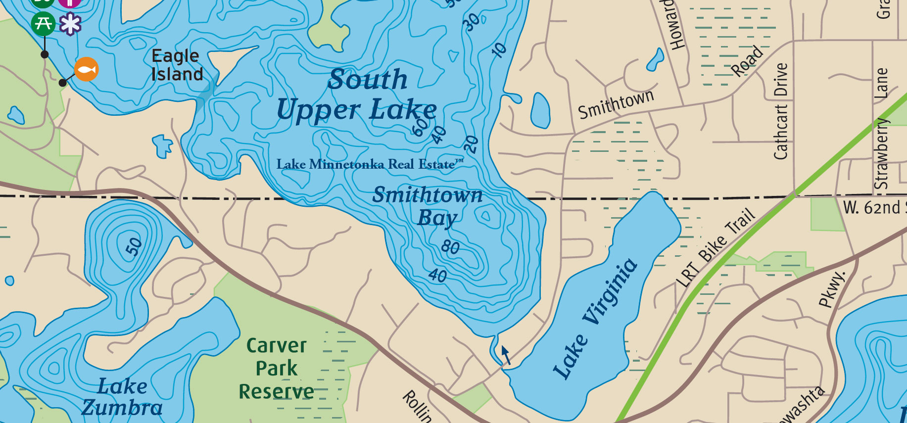
The name recalls Smithtown, a settlement envisioned during the 1850s by the Smith brothers, including Elliot and William Smith, who owned land along the bay. They constructed a mill and two log houses and widened an existing trail from Excelsior to accommodate horse-drawn carriages. The improved route became known as Smithtown Road, a name still found on local maps.
The proposed community never developed as its founders had hoped. Settlers increasingly favored Excelsior, which became an established center of commerce and travel on Lake Minnetonka. Smithtown remained a place on the map rather than a flourishing town, its name surviving principally through the bay and the road.
Today, Smithtown Bay encompasses approximately 114 acres, with 1.22 miles of shoreline and a maximum depth of 88 feet. Its considerable depth contrasts with the smaller inland waters nearby, particularly Lake Virginia.
South Upper Lake
South Upper Lake occupies a broad stretch of Lake Minnetonka's Upper Lake, immediately north of Smithtown Bay and near the boundary between Hennepin County and Carver County. Eagle Island and Crane Island lie along its western approaches, while Wawatasso Island rises from the waters to the north. The eastern shoreline extends toward Smithtown Road and the wooded countryside surrounding Victoria.
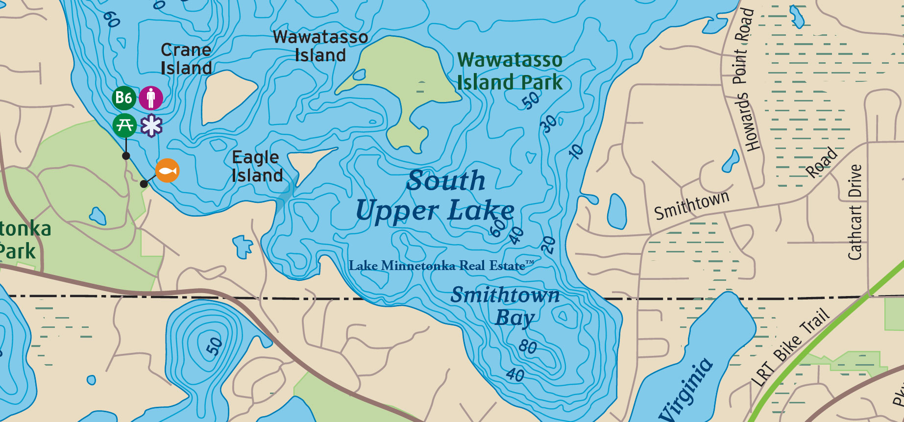
During the nineteenth century, these waters were particularly well known for the birdlife inhabiting the neighboring islands. Crane Island supported an extraordinary colony of great blue herons, and early steamboat passengers sometimes witnessed thousands of birds taking flight when a vessel sounded its whistle nearby. Eagle Island similarly acquired its name from the eagles that once nested there. The islands were landmarks in a part of the lake still characterized by wooded shorelines and relatively few permanent settlements.
Following a destructive storm in the early twentieth century, Crane Island was developed as a summer cottage colony by the Crane Island Association in 1907. Its historic cottages remain part of a community recognized on the National Register of Historic Places. Nearby, Wawatasso Island, once known as Dunlap Island, has a different legacy and is now part of Lake Minnetonka Regional Park, with public access to its wooded shoreline.
South Upper Lake encompasses approximately 710 acres, with 4.95 miles of shoreline and a maximum depth of 67 feet.
Spring Park Bay
Spring Park Bay occupies a central position in the Upper Lake portion of Lake Minnetonka, along the southern shoreline of Spring Park. Black Lake lies to the west, while Casco Point extends into the water from the east. Pelican Point, Pelican Island, and Wild Goose Chase Island define the southern approaches. Along the northern shore, Shoreline Drive follows a waterfront once occupied by some of the lake's best-known resort establishments.

Originally called Byers Bay, the water takes its earlier name from William Byers, who owned approximately 156 acres in this vicinity by 1850. The settlement that became Spring Park was laid out in 1880, its name associated with a natural spring near Casco Point. Two years later, James J. Hill's railroad reached the community, transforming what had been a relatively quiet shoreline into an important destination for visitors arriving from Minneapolis and beyond.
During the 1880s, trains brought hundreds of excursionists to Spring Park, where steamboats met passengers bound for the lake's hotels and summer cottages. The celebrated Hotel Del Otero, with its surrounding cottages and resort grounds, became a prominent waterfront landmark. The hotel survived well beyond the great resort era before being destroyed by fire in 1945.
Today, Spring Park Bay remains a center of boating activity, with a public boat launch and the Hennepin County Sheriff's Water Patrol facilities along its northern shore. The bay encompasses approximately 402 acres, with 2.67 miles of shoreline and a maximum depth of 36 feet.
St. Albans Bay
St. Albans Bay occupies the southeasternmost inlet of Lake Minnetonka, between Excelsior, Greenwood, and Shorewood. Solberg Point separates it from neighboring Excelsior Bay, while Minnetonka Boulevard crosses the narrow passage connecting the two bodies of water. St. Albans Bay Road follows the northern shoreline, and Excelsior Boulevard skirts its southern reaches.

The bay takes its name from the short-lived village of St. Albans, established along its eastern shore in 1855. Named in remembrance of St. Albans, Vermont, the settlement included a sawmill, several homes, Trinity Church, and the St. Albans Inn, built by John McKenzie in 1856. For a time, it appeared capable of becoming a flourishing community. The financial panic of 1857, followed by the destruction of its sawmill in 1859, brought those ambitions to an end. The village disappeared, although its name remained on the water.
During the decades that followed, the surrounding shoreline became part of Lake Minnetonka's growing resort and transportation network. The Minneapolis & St. Louis Railway crossed the entrance to the bay near Solberg Point, where a steamboat landing connected railroad passengers with destinations elsewhere on the lake. Summer boarding houses, cottages, and small resorts appeared along the shore, including May Place and the early Covington development.
Today, St. Albans Bay encompasses approximately 164 acres, with 2.19 miles of shoreline and a maximum depth of 44 feet.
St. Louis Bay
St. Louis Bay lies along the Deephaven shoreline, close to Carsons Bay, the historic neighborhood of Cottagewood and Grandview Point. Its protected waters were part of a shoreline once lined with summer hotels and cottages.
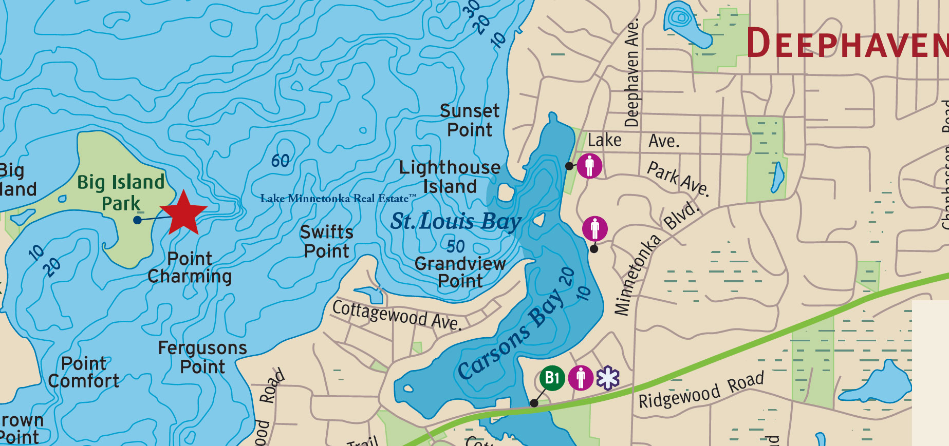
The bay takes its name from the Hotel St. Louis, an early lakeside resort associated with Charles Gibson and the rise of rail-and-steamboat tourism in the late nineteenth century. Visitors traveling from Minneapolis and St. Paul arrived in search of the lake air and summer recreation that made Minnetonka nationally known.
St. Louis Bay is a small basin of approximately 22 acres, with 0.48 miles of shoreline and a maximum depth of 42 feet.
Stubbs Bay
Stubbs Bay occupies the northernmost reaches of Lake Minnetonka, extending into Orono between Bayside Road and Tonkawa Road. Its narrow southern passage connects with Maxwell Bay, while North Arm lies farther west. Classen Creek enters near the northeastern shoreline, and the Luce Line Trail crosses the countryside just beyond the bay's northern end. Sheltered from the lake's larger expanses of open water, Stubbs Bay retains a character quite distinct from its neighboring bays.

Originally known as Teas Bay and later Bean Bay, the water eventually acquired the name of the Stubbs family, among the early settlers and substantial landowners of northern Lake Minnetonka. Henry Stubbs established the Tamarack Post Office at his home in 1856, providing an important connection for families living in what was then a sparsely settled agricultural community.
Another member of the family, Joel Stubbs, was active in horticulture and agricultural innovation. In 1870, he patented equipment for processing sorghum, a crop that briefly became important to local farming. The family's extensive landholdings and agricultural work were part of the settlement history that preceded the summer residences and established lakeshore neighborhoods of modern Orono.
Today, Stubbs Bay encompasses approximately 195 acres, with 2.25 miles of shoreline and a maximum depth of 37 feet.
Tanager Lake
Tanager Lake lies in Orono, immediately north of Browns Bay on Lake Minnetonka. Long Lake Creek enters from the northwest, carrying water through a watershed that extends toward Long Lake and Medina. The Dakota Rail Regional Trail passes along the northern side of the lake, while Shoreline Drive separates it from Browns Bay. A narrow passage beneath the road connects the two bodies of water.
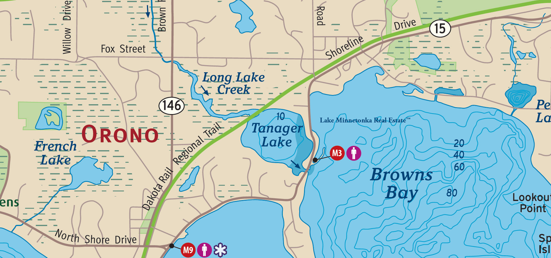
Historically known as Mud Lake and Round Lake, Tanager Lake was part of a landscape of marshes, wooded shoreline, and agricultural land. Its present name is a considerable improvement over the older descriptions, although the precise date and circumstances of the change remain uncertain.
Once surrounded by farms and homesteads, Tanager Lake now lies within an established residential landscape. Its sheltered setting and wetland surroundings distinguish it from the deeper, more open waters of Browns Bay.
Tanager Lake remains an important link between the Long Lake Creek watershed and Lake Minnetonka. It encompasses approximately 54 acres, with 1.07 miles of shoreline and a maximum depth of 23 feet.
Wayzata Bay
Wayzata Bay occupies the northeastern reaches of Lake Minnetonka's Lower Lake, with the historic waterfront of Wayzata extending along its northern shoreline. Ferndale Road approaches from the west, while Bushaway Road follows the eastern shore. Breezy Point and Cedar Point East extend into the bay from Woodland, with Spirit Island farther southwest. The bay opens toward the broader waters of the Lower Lake, while Gleason Lake Creek enters near its northeastern corner.
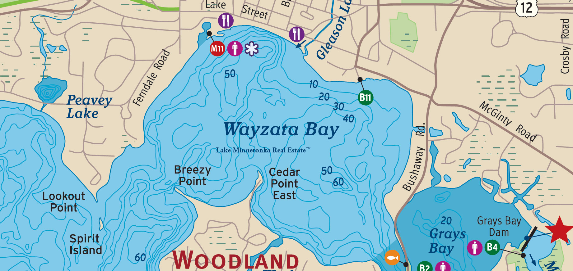
Long before Wayzata became a settlement, these waters were familiar to the Mdewakanton Dakota, who hunted, fished, and harvested the resources of Lake Minnetonka. The peninsula now known as Breezy Point was originally Spirit Knob, a place of particular spiritual significance. When author Elizabeth Fries Ellet visited in 1852, she called the bay Lake Bryant, in honor of the poet William Cullen Bryant.
Oscar E. Garrison laid out the original lots of Wayzata in 1854, but the arrival of the St. Paul & Pacific Railroad in 1867 transformed the settlement's prospects. Passengers arriving by train could board steamboats for hotels, cottages, and settlements throughout Lake Minnetonka. The waterfront became one of the lake's principal transportation centers, eventually marked by the handsome Great Northern Railway Depot completed in 1906.
As the town developed, the surrounding shoreline attracted prominent summer residents, particularly along Ferndale and Bushaway Road. Today, the historic depot, public docks, downtown waterfront, and established residential neighborhoods remain closely connected to the bay's history.
Wayzata Bay encompasses approximately 751 acres, with 3.33 miles of shoreline and a maximum depth of 63 feet.
West Arm
West Arm stretches across the northwestern waters of Lake Minnetonka, between Jennings Bay and Coffee Cove. Woodland Point extends southward toward Harrisons Bay, while Skogsberg Point, Shadywood Point, and Fagerness Point distinguish its northern and eastern shorelines. Deering Island lies toward the eastern end of the arm, where the water narrows before continuing through Coffee Cove toward Crystal Bay.

During the late nineteenth century, the northern shoreline became associated with Erik August Skogsbergh, a Swedish-American minister whose summer property formed part of a Scandinavian retreat known as Saga Hill. Families from Minneapolis and St. Paul gathered here during the summer months, establishing cottages and a community whose history was later recorded by Theodore C. Blegen in The Saga of Saga Hill.
West Arm was also served by the steamboats that made Lake Minnetonka's more distant shores accessible. Among them was the Florence Deering, operated by Captain Charles Deering, whose name survives on Deering Island. The vessel carried passengers through West Arm and the Upper Lake at a time when steamboat travel was central to life on the water.
The surrounding shoreline eventually developed into established residential neighborhoods, particularly around Mound's Three Points and Shadywood Point. Yet West Arm retains much of its geographic character, with broad sheltered water, wooded points, and narrow passages connecting one bay to another.
West Arm encompasses approximately 577 acres, with 4.60 miles of shoreline and a maximum depth of 44 feet.
West Upper Lake
West Upper Lake occupies the western reaches of Lake Minnetonka's Upper Lake, between Halsted Bay and the islands that distinguish its eastern and southern waters. Rocky Reef lies near the western shoreline, while Enchanted Island separates the basin from Phelps Bay. To the south, Crane Island and Wawatasso Island mark the transition toward South Upper Lake. The surrounding shoreline includes portions of Minnetrista and Mound, where some of the lake's earliest agricultural properties eventually became summer retreats and substantial lakeshore residences.

During the nineteenth century, these waters served the growing communities along Lake Minnetonka's western shoreline. Farms and wooded homesteads gradually gave way to summer cottages and country estates as steamboat service made the more distant portions of the lake accessible. Crane Island, once known for its remarkable colony of great blue herons, became a summer cottage community in 1907. Nearby Wawatasso Island, also known historically as Dunlap Island, eventually became part of Lake Minnetonka Regional Park.
West Upper Lake has also attracted some notable residents. Professional wrestler and promoter Vern Gagne once owned lakeshore property that later became part of Lake Minnetonka Regional Park, preserving a portion of the shoreline for public enjoyment. Elsewhere on the lake, record producer Jimmy Jam Harris, whose partnership with Terry Lewis helped define the sound of contemporary popular music, maintained a substantial lakeshore estate. His former property represents a more recent chapter in the history of Lake Minnetonka's remarkable homes.
West Upper Lake encompasses approximately 379 acres, with 5.62 miles of shoreline and a maximum depth of 84 feet.